
|
|
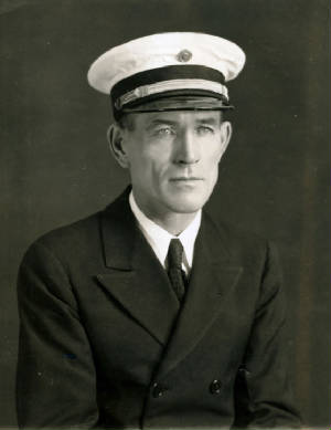
----------------- Amelia Earhart Amelia Earhart, American aviatrix
- Lady Lindy, Queen of the Skies, First Lady of the Air - with her
low-wing twin-engine Lockheed Model
10-E Electra mono-plane. (1936 photo.)
The plane was designed in 1934 and built in 1935. The plane was outfitted
for long-distance flights to Earhart's specifications and delivered to her in July 1936.
In June 1928, Earhart was the first woman passenger on a non-stop flight
across the Atlantic Ocean. (Newfoundland to Wales.) In May 1932, Earhart was the second person to fly solo non-stop across
the Atlantic Ocean, five years after Charles Lindbergh's pioneering
solo flight from New York to Paris in 1927. Earhart flew from Newfoundland
to Ireland, In January 1935, Earhart was the first woman to fly solo from
Honolulu, Hawaii to Oakland, California.
1937 The
World Flight A Great Circle Flight Around
the world by the equator Amelia Earhart set out to fly around the
world by the equator - the longest possible
route. Amelia Earhart and her husband, George Putnam (1887 - 1950),
study a map before the flight. The Lockheed Model 10-E Electra. The
photo was taken in Oakland, California in mid-March 1937 or on Wheeler Field on the Hawaiian island of Oahu on March 18, 1937.
Fifteen planes of this model
were built for a pilot, co-pilot, two navigators, and ten passengers. Passenger
seats were removed from two of the planes to carry extra fuel for long flights. Earhart got one of the two planes. Dick Merrill
and Jack Lambie flew the other plane round-trip across the Atlantic in May 1937. Earhart's plane was
outfitted for the round-the-world flight.
The sketch above points out
the Electra's two engines, pilot escape hatch atop the cockpit (one of the
plane's two entrances or exits), the navigator's station, and location of the
extra fuel tanks in the fuselage (between the cockpit and the navigator's station). The antenna of the plane's Radio Direction Finder (RDF), to assist in navigation
by determining the direction to the source of radio signals, was a manual rotatable hoop above the cockpit, called a "loop
antenna". Omitted from the sketch is
the plane's only door, on the port side. There was a lavatory in the back of the plane. The sketch is of the plane as it
looked in mid- March 1937. Photo of the control panel in
the cockpit of Earhart's Electra. Two seats for pilot, left, and co-pilot, right. The box in the upper
left corner has been described in some accounts as a radio compass receiver. If so, the photo was probably taken in Burbank,
Califonria not later than early March 1937, when the radio compass was removed. Amelia Earhart said the round-the-world flight would be her last exploit
in aviation. She wanted to do other things and continue her work for women and education. She would be age forty at the end
of July. Fred Noonan
Frederick Joseph
Noonan, born in Chicago
on 4 April 1893, was considered the best flight navigator of the day. The above photo is of Noonan
with Pan American Airways. In 1935, Noonan was the first to chart many commercial air routes
across the
Pacific. He trained flight navigators
for Pan Am. Noonan's father was from the state of Maine. His mother came from England with her
family. Noonan moved to Seattle and went to sea in his mid-teens. He sailed on American and British merchant ships (mostly
British) - sailing vessels (windjammers) and steam
and motor ships.
During the Great War, Noonan sailed on American
and British merchant ships. He was a ship's officer on American and British merchant vessels after
the war. By age 30 he was a master mariner - the highest rank, equivalent
to a ship's captain on cargo and passenger ships - with the highest ratings. By the 1930s his license was "unrestricted",
for any ship, "any tonnage, any ocean". In the late 1920s, Noonan was drawn to aviation. He got a commercial pilots's license.
He joined an American airline with air routes to South America. The airline was acquired by Pan American Airways. He
was a navigation instructor and managed Pan Am's airports in Haiti, Cuba and Miami. Noonan
was the navigator on the first Pan Am Clipper flight through Latin America to the Pacific, in 1935. He was the chief navigator on all of Pan
Am's Pacific Survey flights in 1935 and first commercial Clipper flights across the Pacific in 1936. He trained Pan Am's Pacific
Clipper navigators. Noonan did not leave Pan Am but stopped working for the airline in late 1936 when its management did not respond to requests to improve working conditions and the pay of flight crews. Pacific Clipper crews were pushed beyond their physical limits (and beyond
the limits set by government regulations). Noonan planned to open a navigation school. In mid-March 1937,
a few days before the scheduled take-off from Oakland, Amelia Earhart invited Noonan to join the World Flight as its celestial navigator. Oakland, California - Honolulu, Oahu, Hawaii The World Flight crew
before taking off from Oakland, California for Honolulu, Hawaii on 18 March 1937. From left to right are Paul Mantz, co-pilot and technical advisor; Amelia Earhart, pilot; Harry Manning,
radio navigator, and Fred Noonan, celestial navigator. Behind
the crew is Earhart's Lockheed Model 10E Electra. Paul Mantz (1900
- 1965) was a famous Hollywood stunt pilot and air racer. Mantz was Earhart's partner in a brief business venture,
the Earhart-Mantz Flying School, in Burbank, which Mantz directed through his airline, United Air
Services, in 1935. Mantz trained Earhart in long-distance flying. Mantz accompanied the World Flight as
Earhart's technical advisor to Hawaii, where he was
to meet his fiancée. Harry Manning (1897 - 1974) was a cargo and passenger ship captain. He was also an air pilot, radio
operator and navigator. He was a friend of Earhart. He was captain of the ship that brought Earhart back to America after
her passenger ride on a non-stop flight across the Atlantic in 1928. As radio navigator on board the World Flight, he
was to guide Earhart across the entire Pacific Ocean - from
Oakland to Honolulu to Howland Island and Lae, New Guinea. Manning was to go as far as
Darwin, Australia. Fred Noonan was a last-minute addition to the crew. A pioneering flight navigator in the Pacific, his knowledge
and experience were extensive. His quick method of calculation simplified celestial navigation in aviation. (Most celestial
navigators estimated their position from observations of three stars. Noonan was known for two-star position fixes.) A
radio operator and celestial navigator were essential for any flight across the Pacific Ocean. It would be dangerous to attempt
the flight without either. Radio was not always reliable. Initially, Noonan was asked to assist Manning in navigating Earhart
from California
to Honolulu
and Howland - the latter flight a long and difficult stretch over the central Pacific. Manning was
not familiar with multi-engine planes and not experienced in long-distance flying or cross-Pacitic flights. Noonan was to
get off at Howland and return
to California with the Coast
Guard. In
Honolulu, Earhart wisely invited Noonan to continue from Howland to Lae. He was to get off with Manning in Darwin.
Earhart would continue the flight alone from Darwin, fly across Asia,
Africa, the Atlantic, South America, the Caribbean and the U. S. back to California. Earhart billed her World Flight as a scientific expedition and her plane a "Flying Laboratory". In reality, the plan and the flight were nothing of the sort. The claim was a device to obtain
sponsorship from an academic institution. In the back of the plane were stations for the radio and celestial navigators, extra
fuel tanks. and emergency provisions. Paul Mantz, Amelia Earhart and George Putnam Loading the plane in Oakland on 17 March 1937 The Hayward Review
(San Francisco Bay), 23 February 1937. Map shows the planned route of the flight from Oakland, California around the world to the west, starting out across the Pacific.
Six fuel tanks, including four extra large tanks -
three big tanks, shown in the photo above, and one slightly smaller tank - were in the cabin between
the cockpit and the navigator's station. The photo was taken probably in February or early March 1937. The navigator could
climb over the tanks to get to the cockpit or attach notes onto the end of a
long stick, reach over the fuel tanks and hold
it out to the cockpit. Earhart is atop the fuel tanks with a radio that has been described in
some accounts as a radio compass receiver (a navigation homing device). If so, it was removed before the flight. The
radio has been described also as a radio transmitter. (See below.) On 18 March 1937, Earhart, with a crew of four, flew
the first leg of the World Flight from Oakland to Honolulu. There was one technical malfunction during the flight. The
right engine shut down temporarily. Honolulu Paul
Mantz, as the co-pilot, landed the plane at Wheleer Army Air Field, the army's pursuit (fighter) plane base in
northwestern Oahu, on 18 March.
The crew on Oahu on March
18, 1937. From left to right: Manning, Mantz, Earhart and Noonan.
Mantz checked the Electra. There was a problem with the right engine propeller that would have to be repaired.
The next two legs across the Pacific would
be the longest, most difficult and most dangerous of the entire World Flight. No one had flown between Honolulu, Howland and
Lae before. This was a pioneering venture.
The next leg of the flight was to Howland Island, a tiny remote island in the central Pacific.
Earhart and Mantz visited Luke Field, the US Army's main air base on Oahu (for pursuit
planes and bombers), on Ford Island in Pearl Harbor, and decided its runway would be better than Wheeler Field for the
take-off for Howland. The army shared the island, dividing
it in half with the navy, which had its base in Pearl Harbor.
The next day, 19 March, Mantz checked the plane again and took it on a 45-minute test
flgiht over Honolulu.
The
Electra on Wheeler Field. The photo was taken on 19 March, with Paul Mantz (and his fiancée and a friend) on board, before
Mantz tested the plane in flight.
Mantz landed the plane on Luke Field. Further
checks and corrections. There was a problem during refueling. Noonan impressed Earhart and after the flight
from California to Hawaii, Earhart asked him to consider accompanying her the entire flight - across
Asia, Africa and the Americas. The plane would take off before dawn on 20 March for the 11 1/2 to
12-hour-flight in day-time to Howland. On
board with Earhart were Manning and Noonan. The plane was heavily loaded with fuel for the long flight. Earhart,
with Manning as co-pilot, began the night take-off. The plane, with Earhart at the controls, ground-looped on the take-off and crashed. Earhart's Electra after
its crash on Luke Feild on Ford Island in Pearl Harbor on 20 March 1937. There
were no injuries to the crew of three. There were numerous accounts of the crash.
As the
plane accelerated on the take-off roll the left engine
seemed to rotate faster than the right. The plane swayed to the right and headed off the runway. The plane swerved towards
the left and tipped over on its right. The right wing may have clipped the ground. The plane slid sideways down the runway.
The right landing gear collapsed and the right tire burst. Then the left landing gear collapsed. The plane
spun to the right, slid and whirled on its belly down the runway, and came to a stop facing the opposite direction of
the take-off. Earhart
was not sure what caused the accident. She thought the right shock absorber might have collapsed. A tire might have burst.
In a telegcam to Putnam, Mantz said a tire
burst. That same day, Noonan wrote an article for United Press:
He was in the back of the plane at the navigator's station. A tire burst. Taking off with one tire would have necessitated
a crash landing on Howland or a ditching at sea. Earhart controlled the plane, brought it to a stop and limited the damage. Earhart
planned to try again.
The plane was shipped back to Burbank
for repairs.
Manning would not be available for another attempt. His leave from the
shipping company would soon expire. Due to the seasonal change of direction of the winds in the Pacific, the
second attempt around the world would be to the east, starting out from California and flying across the
southern U. S., rather than west over the Pacific. There may have been other reasons
for the change in direction. According to some accounts, there was a possibility the government would ban the flight if
it started again in California and Honolulu. On the second attempt, Earhart was to be accompanied over the entire route by Fred Noonan. 
Amelia Earhart and Fred Noonan in Honolulu after the crash of the Electra, on board the SS Malolo
to San Francisco. Silent
film footage
The Second Attempt On 20 May 1937, Amelia
Earhart set out again on the World Flight. The Putnams lived in the city of Burbank, a suburb of Los Angeles, and
Earhart flew north to Oakland (a large city across San Francisco Bay from the San Francisco Peninsula) in the morning.
Earhart flew back to Burbank in the afternoon on the first leg of the flight (its official start). An engine fire during
refueling delayed the flight in Burbank to the next day. Take-off from Oakland Official start of the World Flight Features Earhart, San
Francisco Bay, and George Putnam in Burbank
Film of Amelia Earhart’s Take-Off Just before the take-off Uploaded by the WSJ in 2015
Fred Noonan was
twice married, the first time in 1927. He had recently remarried. The above photo is of Noonan with his wife,
Beatrice Mary. The couple lived in Oakland. The photo was taken at the airport in Oakland on 20 May or in Burbank on 20 or 21 May 1937.
Earhart,
Putnam, Noonan and a mechanic took off from Burbank on 21 May. They flew east for Miami, Florida. Miami At night, Noonan navigated
the plane across the Gulf of Mexico from New Orleans to Miami. Earhart, Putnam,
Noonan and the mechanic arrived in Miami at dawn on 23 May. The plane landed at the wrong airport. It was closed for the night. In landing at the right
airport shortly afterward, Earhart misjudged her height over the runway and damaged a wheel strut. Amelia
Earhart's Last Flight Documentary (2000) Part
1 of 4 This documentary is about a recreation of Earhart's flight around the world
sixty years later, in 1997. This part, the first fifteen minutes, recollects Earhart's preparation for the 1937 flight.
Earhart and Noonan remained in Miami ten days while numeous changes to the plane were made. The external
changes are known but there is uncertainty about the reported changes to the plane's radio system.
The plane was built in mid-1936 and refit for Earhart with
a single plexiglass window on each side in the back for the celestial navigator to make observations of the sun, moon and
stars. A
second and larger window was added farther back to the starboard side of the
plane, as shown in the photo above taken in a hangar in Burbank. The second window may have been in the lavatory. This window was removed (patched) in Miami before Earhart and
Noonan set out across the Caribbean. The photo above shows the starboard side of Earhart's Lockheed Model
10-E Electra as it looked before the second window on the starboard side was
installed or after it was removed. Thus, in the back of the plane there were two windows, one on each side, and a third window,
in the door, which was on the port side of the plane. The navigator sat at a desk in the back of the plane to make observations through the
windows. An audio intercom system was not on board. The
navigator could check his observations from
the cockpit. Noonan was also a pilot and probably spent much of the World Flight in the cockpit. On 1 June 1937, Earhart and Noonan took off from Miami
for the Caribbean and South America.
They were to fly a path east along an equatorial
route, circling the world as close to the equator as possible. A Great Circle flight. Excerpt from a documentary
Amelia Earhart and Fred Noonan at Parnamerim
airfield, Natal, Brazil, 7 June 1937
St. Louis, Senegal
The flight across the Atlantic -
from Natal in Bahia in Brazil to Senegal - took 12 to 13 hours.
In a letter, Noonan wrote that heavy rains and thick clouds
blinded them for ten hours. The African coast was socked in. The radio was knocked out. They got through, Noonan wrote, by
their "usual luck". The destination was Dakar.
Noonan's chart of the flight, which was sent back to the U. S., showed a planned flight
path from Brazil direct to Dakar - and another flight path, leading to a point on the African coast
several miles to the east and slightly south of Dakar. From this point the chart indicated a turn to the north, by-passing
Dakar, and a continuation to St. Louis,
Senegal, 100 nautical miles farther up the coast to the north of Dakar.
According to a press
release, Earhart landed in St. Louis because Dakar was covered by haze.
According to Earhart's
dispatch to the Herald-Tribune, she sighted
the African coast in heavy haze. Noonan told her to fly south. This would have brought her to Dakar within a half-hour, she
said. Instead, she followed the urge to fly north and soon saw St. Louis. By then, it was too late in the day to turn
round for Dakar.
It has been suggested Earhart chose to land in St. Louis,
which was the regional hub of Air France, to better service the plane.
Earhart and Noonan flew to Dakar the next day.
Fred Noonan and Amelia Earhart in Dakar, Senegal
on 8 - 10 June 1937.
Earhart and Noonan, left of the table, at the Aero
Club in Dakar, Senegal.
Earhart and Noonan at the Aero Club in Dakar, Senegal.
Java
Fred
Noonan in Bandung on Java
in the Dutch East Indies in
late June 1937.
Darwin, Australia
Amelia Earhart and Fred Noonan, on the right
in the above photo, in Darwin, Australia on 28 - 29 June 1937.
Parachutes are on the ground.
George Putnam wanted his wife to hurry home
for the 4th of July. He had made preparations for her to attend a radio event. Earhart
and Noonan took off from the port of Darwin in the Northern Territory of Australia on the morning of 29 June. They flew to the
port town of Lae at the eastern end of the island of Papua - at the time administered by Australia
as the Territory of Papua - and landed at 3:00 p.
m. The flight, 1,040 nautical miles (1,200 statute miles), took seven hours and forty-three
minutes.
Lae, New Guinea Amelia Earhart and her Electra arrive in Lae, New Guinea
on 29 June 1937.
Map charting the path of Amelia Earhart and Fred Noonan on their
round-the-world flight by the equator in 1937. Departing from Oakland, California on 20 May and Miami, Florida on 1 June,
they flew across the Caribbean Sea, the northeast coast of South America, the Atlantic, Africa, the southern coast of Arabia,
the north of India (Karachi and Calcutta), Southeast Asia (Burma, Siam, British Malaya and the Butch East Indies), and arrived
in Darwin, Australia on 28 June and Lae on Papua on 29 June. They took off from Lae at noon on 2 July
and headed east for the central Pacific. Earhart and Noonan had flown three-quarters
of the way around the world. The next three legs of the World Flight would be the last. This would
be the longest stretch of the flight, totalling 5,966 nautical miles (or 6,866 statute
miles): 1. Lae to Howland Island - 2,221 nautical miles or 2,556 statute miles (almost entirely
over water); 2. Howland to Honolulu - 1,651 nm or 1,900 statute miles (the entire flight over
water); and 3. Honolulu to Oakland, California - 2.094 nm/2,410
miles (the entire flight over water). The next two legs -
from Lae to Howland and Howland to Honolulu - would be the most difficult and most hazardous of the
entire flight. No plane had flown between those points before.
The flight from Lae to Howland would be the most difficult
of all.
Howland Island (in the middle of the globe above) is just north of the equator and about 200 nautical
miles east of the 180th Meridian, the International Date Line (IDL). Earhart wanted to depart for Howland the next day, 30 June. With
all that had to be done, however, that would not be possible. There are numerous accounts of Earhart's and Noonan's preparations
in Lae for their flight to Howland. There are Earhart's letters, telegrams and a dispatch to a newspaper; Putnam's telegrams; US Navy and Coast
Guard telegrams; messages logged by radio operators; and reports by two persons directly involved in Lae. The telegrams
and reports are often cited as the most important accounts. A report was presented with a letter by Eric Chater, manager of Guinea Airways in Lae, to the San Francisco
office of a mining company involved in gold mining in New Guinea, on 25 July 1937. The letter was found in the company's office
files in Vancouver, British Columbia in 1992. Chater sent a report also to Putnam. At the time, in 1937, Lae was a
gold rush town, at the centre of gold mining operations, with a busy airfield and many planes and pilots. Another report was presented by a government official, James A. Callopy, the local district superintendent
for civil aviation, in a letter to his superior, on 28 August 1937. Callopy's report and Chater's report to the gold mining company differ in their descriptions of
Earhart's take-off from Lae and radio messages during the first seven hours of the flight. Earhart had dinner with the Chaters at their home in Lae. Noonan passed the evening with Callopy and
another pilot. At
6:30 the next morning, on 30 June, Earhart sent a telegram to Putnam, in Oakland, California, to inform him of a delay:
"Radio misunderstanding
and personnel unfitness. Probably will hold one day."
The telegram
requested a weather forecast from Howland (or Honolulu) and, also, a meteorological report from Howland
for Noonan. There
should not appear to be any reason to dwell on this telegram. There was some question about radio procedures
that should be answered in a day or so. The crew were fatigued and needed another night's rest. Decades later cranks made much of the telegram to spread malicious gossip. Thus, it cannot be omitted
from an account of Earhart in Lae. There were numerous problems with the plane during the journey
from Natal to Lae. Radio was the biggest problem. Radio is considered to have determined the outcome of the flight across the Pacific. The plane was often without radio contact as it flew around the world. The pilot followed
the magnetic compass and geographical features. The navigator estimated their position by celestial observations (the
sun, moon and stars) and dead reckoning (a calculation of distance from point
to point by the time of the run, the speed of the plane and the speed of the winds). Over the vast Pacific Ocean, without
recognisable geographical features, the absence of radio contact could doom a flight. Earhart's telegram to Putnam applied to the next
leg of the flight, from Lae to Howland Island, and "radio misunderstanding" implied a lack of agreement over
radio broadcast schedules, signals and frequencies with radio operators along the flight path. It was often said that Earhart did not understand sufficiently her radio and the use of radio in general
- and that she did not care enough about it. Over the Pacific this could be fatal.
If there was a "radio misunderstanding",
it was at Earhart's end. Earhart was ill with dysentery five days earlier. Her telegram implied that the crew were not well.
Noonan was in good health throughout the venture. If someone was unfit, it was Earhart and her unfitness may have impaired her judgement in the week before
the flight. From
Lae to Howland Island, Earhart was to be in contact with three radio stations, each at a different point. The first was the Guinea Airways
radio station at the point of departure on the airfield in Lae. The second was the USS Ontario, a naval vessel stationed as a radio beacon in the open sea at mid-point
along the flight path to Howland. The third was at destination, Howland Island, where the US Coast Guard Cutter Itasca was stationed
on "plane guard" and to serve as a radio beacon and, if necessary, guide the plane to the island. This was a radio agreement that
would not - or could not - be followed to the extent required. A US government official on Howland,
Richard Blackburn Black, was the Putnams' personal contact and representative on the Itasca and Howland Island. Black
was responsible also for all arrangements on the Itasca, Howland and the flight path across the Pacific from Lae
to Honolulu. He relayed telegrams to and from the Putnams. Radio
There are many accounts of the radio systems
on board the plane. They differ considerably. The systems were changed at least once in the U. S. and some modifications may
have been made en route. The plane had a radio
transmitter, receiver and navigation aid. Each had its own antenna
or antennae. Their specifications and capabilities are unclear, however. During the flight from Lae to Howland, sporadic messages were received from the plane in the first seven hours and last five hours. It is possible the radio receiver did not work until the last hour. Or
Earhart did not care to acknowledge messages until then. In the end, only
the navigation aid - a homing
device that never worked during the entire journey - could decide the fate of the crew. How the radios and antennae were selected, removed, replaced or modified
in the U. S. and en route is not clear. Numerous experts were consulted. In some accounts, Lockheed delivered the plane in July 1936 with a Western
Electric Company radio transmitter and receiver and the Bendix Corporation replaced them in 1937. By some accounts, Earhart
and Putnam received $5,000 from Bendix, one of the World Flight's sponsors, to remove the Western Electric equipment and install
Bendix equipment to advertise the company. A radio technician in Darwin reported all radio equipment on board was Bendix.
It is generally accepted, however, that a
Western Electric transmitter and a Bendix receiver were
on the plane in Lae. As in March, before the crash in Honolulu, there were three antennae -
for transmitting, receiving
and navigation. A telegraph set could be plugged into the transmitter to tap out signals in Morse Code on a key by
hand. A telephone (microphone and earphones)
could be plugged into the radio (transmitter and receiver) for broadcasts and two-way communication by voice. The navigation aid, a
homing device installed by Bendix, was an antenna in the shape of a hoop called a "loop antenna", above the cockpit, for finding the direction
of radio signals transmitted by a beacon. The loop was connected directly to the radio receiver in the cockpit. One or
two more antennae may
have been used for
the purpose.
Sketch
of the Electra during the first attempt of the World Flight in March 1937 shows the Bendix Radio Direction Finder, a manual
rotatable loop antenna atop the cockpit; the radio receiving long wire antenna under the fuselage; and the radio transmitting
wire V-type antenna atop the fuselage. This sketch omits the port-side door. Accounts of the 50-watt transmitter's specifications differ, probably because some believe it was made by
Western Electric and others by Bendix. There were reports that the original Western Electric transmitter was replaced
by another Western Electric transmitter in February 1937. The transmitter had at least three separate bands (or channels). It may
have had six. One band covered a range of low frequencies
from 325 - 500 kilo (k) cycles (c) per second (s) - kcs. This band was used in maritime and aeronautical radio navigation. A low frequency was any frequency on or below 1500 kcs. (200-metre wavelength). A high frequency was any
frequency 1500 or above. The lower the frequency the longer the wavelength. The higher the frequency the shorter the
wavelength. There are advantages and disadvantages to both. Generally, longwave - low frequency
- travels farther and provides better reception. Shortwave - high frequency
- is often better during the day. Pilots contacted the ground on a low frequency. Pilots contacted each other
over short distances on a high frequency by radio telephone. Two bands, for broadcasting, covered a range of high frequencies from 2500 - 6500 kcs., with one band
for frequencies around 3000 and the other around 6000. Some believe the transmitter had only three bands and they were fixed
("crystal-controlled") to one frequency each - 500, 3105 and 6210 - but could
be calibrated to other frequencies prior to flight.
Others beleive each band could be tuned to various frequencies in flight. The radio transmitter's antenna was a long wire strung across the top of
the fuselage to the tail wings in a triangular V shape, known as a V-type antenna. It was called also a "fixed antenna". It
could not be adjusted in flight. (See sketch above.) According to some accounts
the Western Electric radio receiver delivered with the plane in 1936 was replaced by Bendix before or after the crash in Honolulu
in March 1937. The Bendix radio receiver has been described as an "all-wave" receiver
with four separate bands, each with a different range of frequencies. Two bands for low frequencies: 188 - 420 kcs. and 485
- 1200 kcs. Two bands for high frequencies: 1500 - 4000 kcs. and 4000 - 10000 kcs. Each band could be turned to various frequencies
in flight. By some accounts, the receiver had five bands, the first three
bands to 4000 and the fourth and fifth bands from 4000 to 10000. By
other accounts, there were six bands, covering a range of frequencies from 150 to 15000 kcs. The first three bands were
for low frequencies 150 to 315, 315 to 680 and 680 to 1500. The last three bands were for high frequencies 1800 to 3700, 3700
to 7500 and 7500 to 15000. The receiving antenna was a long wire strung under the belly
of the fuselage. It was called also the "trailing antenna" (TA) - the long wire trailing under
the fuselage. (See sketch above.) Transmitting and receiving low-frequency signals -
longwave - require longer antennae. The receiving antenna was reeled out in series, mechanically or
by hand, after take-off and reeled in before landing. Apparently, its length could be adjusted in flight to receive a certain
high or low frequency. Some believe the TA was destroyed in the crash in Honolulu and
not replaced. Others believe a new wire antenna was installed but removed later in Miami or some time before Lae. There
were reports that it was shortened in Darwin. Some believe it was on the plane in Lae. Some believe Earhart removed it entirely
and used the transmitting wire V antenna atop the fuselage for both transmitting and receiving. Some believe Earhart
used the radio direction finding loop antenna also
as a receiving antenna. Some believe there were two seperate receiving wire antennae on the plane in
Lae - an adjustable long wire (TA) for low frequencies and an adjustable short wire for
high frequencies, both under the fuselage. Some believe the long wire was removed and only a short wire was in place,
either adjustable if under the fuselage or fixed if on one side of the fuselage. Some believe there was only a short fixed
wire under the plane in Lae. In general, the plane transmitted and received on
the low frequency of 500 and the high frequencies of 3105 kcs. and 6210 kcs. The radio
could receive on any frequency. In the U. S., 3105 kcs. was the common aeronautical calling and working
frequency and 6210 kcs. was an alternate frequency for use only during the day. Earhart preferred the higher frequency by
day. All ships at sea kept watch for signals in Morse Code on 500 kcs. - the international
initial contact and emergency distress frequency. Ships made contact on 500 kcs. and agreed to continue on another low frequency.
Long
tones or signals in Morse Code on low frequencies, usually around or below 500, were used by ships also for navigation
- finding the direction to the source of radio signals. Thus, it was particularly important for a plane flying over the ocean, especially the vast Pacific,
to transmit and receive on 500 kcs. and other low frequencies. The ability - or inability -
to transmit and receive on 500 kcs. and other low frequencies -
would be seen as the crux of the communication matter on the flight across the Pacific. The plane's radio transmitted and received Morse Code signals by telegraph
on 500 kcs. It was possible to transmit messages by voice over the radio telephone
on 500. Generally, 500 kcs. was for Morse Code. Signals in
Morse Code sent by telegraph were much more reliable and travelled much farther than messages by voice over the radio telephone.
By some accounts, the long receiving wire antenna (TA) contained a "loading
coil" that received 500 kcs. By some accounts, Earhart removed the long receiving wire antenna
(TA) and shortened the transmitting V antenna, thus giving up her radio's 500 kcs. and low frequency capability,
and discarded the plane's telegraph sets because she did not know Morse Code. Earhart had a radio licence that
required proficiency in the use of Morse Code and communication by voice. In telegrams, Earhart instructed radio operators
to transmit
messages to her in Morse Code at the rate of 15 words per minute. For some reason or other, before the departure from Lae,
the US Coast Guard, responsible
for the "plane guard" on
the flight path, doubted
Earhart's ability, questioned her instructions and decided to reduce the rate to ten words per minute. The change may have
been prompted by Putnam. Paul Mantz was to train
Earhart in the use of her radio. It was said, however, that Earhart cut classes to attend publicity gatherings. Apparently, Earhart had to renew her pilot's licence in the U. S. just before her first attempt on the World
Flight and persuaded officials or the examiner to forego the radio and flight tests before certifying her.
In any case, ships at sea often replied in Morse Code at the slow rate of two words
per minute. Like most pilots, Earhart preferred communication by radio telephone. It
was often impractical for a pilot to tap out and write
out messages in Morse Code, especially during turbulence.
Some believe that without Harry Manning, who was to have been the plane's radio
operator, Earhart felt the telegraph sets were useless and dead
weight.
If so, Earhart was living in the future. Morse Code was widely in use and the most common way to communicate at sea
and in the air over the sea. When weather conditions interfered with celestial observation and dead reckoning the radio was essential. In bad weather, Morse Code signals by telegraph were
much more reliable than voice by the radio telephone. If Earhart could not transmit messages by telegraph, she could send signals
in Morse Code over the radio telephone by playing with the microphone switch. She could hold the switch down to produce a
long tone.
There were claims also that Noonan did not know Morse
Code. This is unlikely. Noonan had many years of experience at sea and in the air. He was a licensed captain of ships. He
had a commerical airplane pilot's license. As required of air pilots, Noonan had also a radio licence that required proficiency
in the use of Morse Code and communication by voice. Noonan could send and read 16 to 20 words per minute in Morse Code. In
1937, a professional radio operator in the U. S. was required to transmit and receive at least 25 words per minute in plain
text. Noonan had his own Morse key set but, as far as is known, a telegraph
set was not on the plane in Darwin and Lae. No one recalled seeing a telegraph set on board. The transmitter and receiver could not be operated simultaneously. The radio operator switched the radio
from one to the other - from the transmitting wire antenna to the receiving wire antenna. Both had
separate relays to the radio in the cockpit. The loop antenna, however, was connected directly to the radio receiver,
through its own relay and operated by a separate switch. Radio navigation device The plane's radio navigation aid - a homing device known as a "radio direction finder" (RDF) -
was used on land, in the air and at sea. This instrument detected the direction of radio signals to assist a plane in navigating to its
destination. Details of this device on
Earhart's plane, especially its capabilities, are
unclear.
Radio
compass Initially, Earhart had a Bendix radio compass, designed
in 1935 and installed in October
1936. The
radio compass system indicated the direction to the source of radio signals. The radio compass had its own receiver. The radio compass system required
two antennae. The radio compass
was connected to a short fixed wire antenna, called a "sense" (sensitive) antenna,
on the
port side of the fuselage, by which the radio operator listened to the radio signals. This sense antenna was "non-directional"
- it did not indicate the direction of the signals. The radio compass receiver was connected
also to a manual rotatable direction-finding antenna - a small loop within a "streamlined" housing -
above the navigator's station in the cabin. The loop antenna indicated the directions of the signals on a 180-degree
baseline but not their source. The radio operator switched from
the sense antenna to the loop antenna or listemed to both simultaneously (it is not clear which). The combination of the sense
wire antenna and loop antennae (DF) enabled the radio operator to determine the exact direction to the source of the signals.
In 1937, the system was not yet "automatic". (Source: F. Hooven.)
Radio Direction Finder (RDF) In early March 1937, before the first World
Flight attempt, Earhart and Putnam removed the Bendix radio compass and installed a Bendix Radio Direction Finder (RDF). They removed the loop antenna (DF) and
housing above the navigator's station and installed a larger loop without housing above the cockpit. They removed the short sense wire antenna
on one side of the fuselage. Some beleive they kept
it. The radio operator would connect the radio receiver to the long receiving
wire antenna (TA) to listen for radio signals and then switch to the loop antenna (DF) to find their direction. The loop antenna indicated the directions of the signals on a baseline. The
baseline was detected by manually rotating the loop antenna - or flying a circle with the plane
- and listening for the strongest points ("peaks") and weakest points ("nulls") of the signals. This was called "taking a bearing".
The weakest point ("null") indicated the directions of the baseline
of the signals. If the signals were strongest when the loop or plane was turned to the north and weakest when the loop or plane was turned to the east, the signals were coming from the east or west. This was called
"getting a minimum". This type of DF was known also as a "null"-type. Finding the "null" or "minimum" could take a minute or more. The direction to the source of the signals was not known. The signals were
coming from one direction or the other - opposite directions - on a straight
180-degree baseline. In most cases, the radio operator on board knew the source of signals could only
be ahead of the plane and not behind it. In some cases, however, a radio operator might not know if the source of
radio signals was ahead of the plane or behind it. The radio signals were coming from one side of the plane or the other.
The plane might have passed it. Once the radio operator detected the baseline of the radio signals, trigonometry
was applied to determine the direction to
the source. The radio operator took a second bearing from a different
point or angle. The point of intersection of the two bearings indicated the position of the source. Removing the radio compass system may have been a mistake. The radio compass
indicated the direction to the source of the radio signals. The RDF system indicated only their baseline. Apparently, the
Putnams were not impressed. Getting a second bearing and finding the direction to
the source of signals by triangulation might take some time but the result should be the same. Earhart claimed the
radio compass, which weighed 30 pounds, was too heavy. This may have been a polite excuse, however. Perhaps it did not work
as well as expected. Money may have been involved. Airfields had radio beacons and RDFs to guide planes. A plane's RDF could
take beatings on a signal broadcast by a beacon to identify its direction. If a plane's radio transmitted a message by voice on the radio telephone or signals in Morse Code by telegraph (usually
the latter) long enough, the operator of the RDF at an airfield could take a bearing on the plane, identify the
direction to it, call it by radio and give it instructions to the airfield.
RDFs were not always accurate. RDFs were known to err, especially at longer
distances. RDFs had to be cross-checked by celestial observations and dead reckoning. That was one reason Earhart and Putnam
hired Noonan for the first attempt of the World Flight. By some accounts, the loop antenna could be used also as an auxiliary
receiving antenna. Its range of frequencies as a receiving antenna is unclear. Some believe the loop antenna could receive
the same range of frequencies as the radio receiver. For direction-finding purposes, however, a loop antenna operated only
on low frequencies on or below 1500 kcs. and worked best within close range of a radio station's transmitter, within perhaps 50
to 100 miles. This was so with the radio compass also. Whatever signals they received, neither could operate on high frequencies or from a great distance. As far as is known, a small loop antenna capable
of taking a bearing on a signal above 1800 kcs. has never been developed. For the second attempt of the World Flight, Earhart planned to broadcast
on 3105 by night and 6210 by day and use her receiver mostly for direction finding. She would broadcast reports and take bearings.
She requested that all communication be in voice over the radio telephone ("In English") and not in Morse Code by telegraph
("Not Code"). In telegrams, Putnam specified that Earhart's RDF operated within a range of low frequencies from 200 to 1400 kcs. Earhart said 200 to 1500 kcs. Either would
be correct. Generally, it is believed its range was 200 to 1430, as for the flight to Honolulu in March. As
noted above, ships at sea, keeping watch for contact requests and emergency distress calls in Morse signals on 500 kcs.,
used low frequencies also for homing in navigation. Most ships had an RDF operating
within a range of low frequencies not higher than 550 kcs.
When approaching, Earhart could contact the ship on 500 kcs. and both could take bearings on another low
frequency, usually around 500 kcs. Whether or not Earhart knew Morse
Code, she could take a bearing on signals sent in Morse or a long tone. She could leave the microphone switch down, producing
a long continuous tone, for a ship to take a bearing on her. Some believe there was a short fixed wire antenna on one side of the plane
solely for 500 kcs. For reasons that are not clear, it was claimed that Earhart's ability
to transmit and receive on 500 kcs. during
the second attempt was reduced and very limited or non-existent. In mid-June, as Earhart
and Noonan flew over India and Burma, Putnam warned that Earhart's 500 kcs. was of "dubious usability". If Earhart could not transmit or receive on 500 kcs., she was unlikely to transmit
or receive on other low frequencies. She would not hear the low-frequency signals in the receiver from a receiving
wire. She would not hear signals on low frequences from the loop antenna and thus she would be unable to take bearings
on low-frequency signals from ships. She would be unable to transmit signals on low frequencies for ships to take bearings
on her. The response from the Putnams' go-between aboard the Itasca, Richard Black: "Try 500 kcs. close
in." That was the general practice. Whatever Earhart may have said on the phone to her husband, she never
indicated in her telegrams that her radio receiver and transmitter on 500 or other low frequencies were faulty or not
performing. If Earhart was without 500 kcs, the radio transmitter and receiver
or antennae were changed or adjusted before departing Burbank or Miami or developed malfunctions en route. If the radio was not changed and
it functioned properly but Earhart could not transmit or receive on 500 kcs., the long receiving wire antenna was shortened or removed and the transmitting V antenna was shortened. If so, Earhart would still receive low-frequency signals by the loop antenna, whcih was connected by
a seperate relay directly to the radio receiver, and she could take bearings on the signals. If the radio receiver could not
receive 500 kcs. or other low frequencies, Earhart could not receive and take bearings on low-frequency signals. If Earhart could not transmit on 500 kcs. or other low frequencies she might not
be able to contact ships at sea.
On
the flight from California to Honolulu in March, Manning took a bearing on signals from a beacon on 290 kcs. as the plane
approached Oahu. The next and second leg of the flight did
not get off the ground. If the flight to Howland had proceeded as planned, Manning would take bearings on signals on 375 kcs.
from Coast Guard cutters stationed on plane guard at Howland and along the way.
Whatever
changes were made to the radio system, by the end of June, Earhart claimed she had a high-frequency RDF. In telegrams, she
claimed its range
of frequencies was 200 to 1500 and 2400 to 4800 kcs.
Whether or not Earhart had in fact a high-frequency RDF with a range
of 2400 to 4800 is not at all certain. Few believe it. Her claim was probably false. But if her RDF was high-frequency,
Earhart could take bearings on radio broadcasts on 3105 kcs. That
may have been to say, however, that Earhart would not have to take bearings on low frequencies. The loop antenna might receive high-frequency signals but for direction-finding
it was limited to low frequencies up to 1500 and worked only within close range of a radio station
transmitter. In close, however, it might work with strong signals in Morse on 3105.
This was perhaps what Earhart had in mind. (Source:
F. Hooven.) After the crash in Honolulu, the plane was repaired in Burbank. Some
had the impression its radio's capability was reduced; this was to be corrected in Miami but further reduced instead. Some believe the Putnams were told the loop antenna might serve as an auxiliary
receiving antenna and assumed it would also take bearings on high-frequency signals. This seems unlikely. Some
wondered if the Putnams were misled by radio technicians who claimed they could reconfigure the RDF system to take bearings
on frequencies above 1500 kcs. This too seems unlikely. Some
believe the Putnams were paid by Bendix to replace one RDF system with a less reliable or non-functioning one in Miami.
The Bendix radio compass, installed earlier, was developed with the US Army. The Bendix RDF was developed
with the US Navy. The navy may have persuaded the Putnams to replace the radio compass with the RDF. Some wondered
if the navy was involved in installing an "experimental" "high-frequency" RDF on the plane. That is possible. There were
such RDFs but their reliability was uncertain. Bearings on high-frequency signals were considered unreliable, especially
beyond their optical range, particularly in the early morning. By
the time the plane reached Lae, Earhart should have known just what her loop antenna could do and could not do. Apparently, she was never able to test it (properly) during the second
attempt. She never got a bearing. A loop antenna was used to receive only. It was not used to transmit. Indeed, the specifications of Earhart's radio system in Lae are not at
all clear. The radio and antennae should have been thus, as on the flight to
Honolulu and as it prepared to fly to Howland in March 1937:
Transmitter (LF and HF) (tunable) (telegraph
and telephone); Receiver (LF and HF) (tunable) (telegraph and telephone; direction finder);
Antennae: 1.
V (Transmitting) atop plane (LF and HF) (fixed); 2. TA (Receiving) under plane - long (LF and HF) (adjustable); 3.
Loop (DF) LF 200 - 1430. For the flight in March from Honolulu to Howland and Lae, which ended
in a crash on take-off, Manning was to transmit and receive messages by voice and telegraph on 3105 by night and 6210 by day.
Over long distances, Mose Code only. In close, 500 - in Morse Code only. Manning would take bearings
on signals transmitted by Coast Guard ships on 375 kcs. (Source: E. Long.) All
things considered, before leaving Lae the plane's radio system was probably thus: Transmitter
(HF or LF and HF) (tunable) (telephone only); Receiver (HF or LF and HF) (tunable) (telegraph and telephone; direction
finder); Antennae: 1.
V (Transmitting) atop plane (HF or LF and HF) (also receiving?) (fixed); 2. (?) TA (Receiving) under
plane - long (LF or LF and HF) (adjustable) or short (HF) (fixed? or adjustable); 3.
Loop (DF?) LF 200 - 1430 (or 1500?) and HF? 2400 - 4800 ("any frequencies not near ends suitable) (also
for receiving? distance?); 4. (?) short wire on side (500 kcs, sense [DF] or HF) (fixed). Earhart
may have left Lae with only: Transmitter (HF) (tunable) (telephone only); Receiver
(HF) (tunable) (telephone and telegraph, direction finder); Antennae: 1.
V (Transmitting/Receiving) atop plane (HF) (fixed); 2. Loop (Receiving [HF])
(range?). The radio logs indicate the plane may have been unable to transmit and receive low frequency signals. The relay from the receiving wire antenna to the receiver may have been faulty and it is possible that only the loop
antenna could receive (Source: A. Gray). The RDF did not work. Some
believe the radio system was adequate and functioning but Earhart did not know how to use it. The additional job of radio
operator may have been too much for her. Some believe the radio system was faulty and inadequate and Earhart did not
care - and her description of it fiction. Earhart
had problems with her radio and RDF throughout the World Flight. This was to be expected of any radio on a
plane at the time. Radios
required frequent adjustments, repairs and changes. On the flight across the Atlantic, from Brazil to Senegal, all radio systems
failed. On the flight from the island of Timor in the Dutch East Indies to Darwin, the
radio did not work. Apparently, a fuse blew. It was replaced and the radio was checked by an army radio techincian in Darwin. On the flight from Darwin to Lae, Earhart was in radio contact with Darwin
but could not contact Lae. Thus, she could not test her RDF as she approached Lae. This was Earhart's fault.
Before departing Darwin, Earhart sent wrong instructions for the use of radio frequencies to Lae.
She wanted to send and receive on 6210. Apparently, in converting the frequency in kilocycles to wavelength in metres she
miscalculated and specified an incorrect wavelength. Thus, Lae did not hear her broadcasts on 6210. She did not hear
Lae. Several days earlier, on Java in the Dutch East Indies, Earhart sent odd instructions to two ships stationed in the Pacific to assist her
in taking bearings. Initially, it was suggested, in Navy telegrams, that the ships could stand by on 333, 400, 545 or other
close frequencies. The Itasca and the Ontario could stand by on 400 kcs. Earhart could contact the ships
on those frequencies. She might also take bearings on those or other low frequencies.
Converting wavelengths into frequencies Earhart gave kilocycles and metres the same number value. Thus, in her instructions to the
Itasca, she changed 400 kcs. - 750 metres - to 750 kcs., and
then, for some reason or other, adding nought, to 7500. In
her instructions to the USS Swan, a naval vessel between Howland and Honolulu,
333 kcs. - wavelength 900 metres - became 900
kcs. and then, again, adding nought, 9000 kcs. (Source: A. Gray.)
The Itasca and the Swan
could receive and transmit on the high frequencies requested by Earhart. The frequencies were within the range of their
radio capabilities. However, radio signals transmitted on high frequencies were less reliable than signals on low frequencies.
Contacting a ship on a low frequency would be better. Taking bearings on such high frequencies was out of the question.
(Source: A. Gray.) Earhart was ill at the time. Were her specifications miscalculations? Did she know what she was doing? The USS Ontario, was to stand by on 400 kcs. The ship had high-frequency, but it was limited to
reception on 3000 kcs. and could not transmit on high-frequencies. Thus, Earhart agreed to 400 kcs. She did not ask the Ontario
to send messages on 7500 kcs.
Did
Earhart intend to take bearings on high-frequency signals? A
loop antenna might receive high frequency signals but it could not take bearings on frequencies higher than 1500 kcs. unless
close to the transmitter and the signals strong. Perhaps on 3105 but certainly not 7500 or 9000.
Earhart's
odd request for contact on 7500 and 9000 was questioned. The commander of the Itasca expressed concern for
the flight's safety.
From
Lae, Earhart asked the Itasca also to send the latest weather reports from Howland to Lae (Guinea Airways radio station)
by shortwave on the 25-metre band (11600 to 12100 kilocycles), or the 46-metre band (around 6500 kilocycles). The Itasca could not transmit directly over such a long distance, something
Earhart apparently did not understand. Earhart
may have come to her senses towards the end of her stay in Lae. In her final instructions to the Itasca, sent twice,
Earhart did not mention 7500. Plane and ship would transmit and receive on 3105 and 6210. Earhart asked the ship to send a
long continuous signal on 3105 as she approached the island. Apparently, she intended to take a bearing on the signal. By
then, however, the commander of the Itasca may have had enough. He replied but did not acknowledge Earhart's request
for a long continuous tone on 3105. The Itasca transmitted on 7500, as requested previously, but never a long tone on 3105. Telegrams make clear that any "radio misunderstanding"
from Lae to Howland was Earhart's. She should have realised this
before setting out. She did not care about the technical matters of radio. Or she was ill. She failed to check with Noonan
before sending her telegrams. It appears that the radio operators for Guinea Airways, the Ontario and the Itasca acted
according to plan. The extent to which the three stations may have been responsible
for radio communication failures is not certain. The Itasca
is often criticised and there are questions about Lae and the Ontario. It is clear, however,
that Richard Black, the Putnams' personal go-between for the next two legs of the flight across the Pacific, did
not make proper and adequate preparations for the use of radio. (See below.) Earhart failed in her first attempt
to reach Howland. Now, Earhart was to try for Howland once more, this time from Lae. The plane on take-off would be
overloaded with fuel, more than it had been in Honolulu. The route was longer. This
time, Earhart was without a radio operator and the radios on board were not very reliable. As
the celestial navigator on Pan Am's Pacific Clipper flights, Noonan worked closely with the radio navigator on board. He understood
radio navigation thoroughly. Initially, two-way radio and the RDF controls were installed in the back of the plane for Manning.
He worked closely with Noonan on the flight from California to Hawaii. When Manning left the flight, his job went to Noonan.
However, Earhart and Putnam had the radio operator's radio and the RDF controls removed from the back and RDF controls reinstalled
in the cockpit. Earhart would control all radio operations herself. No radio equipment was left for Noonan. This was
a mistake. Noonan had far more experience with the radio operations of long-distance flights across the Pacific. Earhart was repeatedly advised of the need for an expert radio operator on board over
the Pacific to handle all radio matters, especially pre-flight preparations and communication in Morse Code during the
flight. Indeed, Earhart
caused the radio communication failure on the flight
from Darwin to Lae before she took off. Did Earhart and Putnam hope to recruit a radio operator and install better
radio equipment before the plane took off from Lae? No radio operator would join a flight that was without 500 kcs., low frequency,
a telegraph set and a reliable RDF.
No
radio operator would go if arrangements with radio operators along the flight path were incomplete
or impractical. Correcting
the situation would require more
money, add weight and prolong the delay. It appears that Earhart was not
counting much on radio communication, if at all. She had made it this far. She believed Noonan would get her the rest of the
way by celestial observations and dead reckoning. Callopy: "Mr. Noonan told
me that he was not a bit anxious about the flight to Howland Island and was quite confident that he would have little difficulty
in locating it." Earhart's
health Earhart was
ill with dysentery five days earlier on Java. Earhart was aware that the "radio misunderstanding" was hers but her telegram
implied that others were responsible. Earhart may have been ill but "personnel unfitness" implied that another was not well.
Perhaps Earhart
meant "personal unfitness". One would
assume that if Earhart were ill - or not feeling well - she would say so.
Perhaps Earhart or the telegraph operator misspelled the word. Otherwise, Earhart's telegram could be considered a display
of poor manners.
Was
Earhart having second thoughts about the flight to Howland? Was she in over her head? Perhaps Earhart never intended to go through with the flight. Was it her
plan all along to terminate the flight in Lae? Was her ground-loop in Honolulu deliberate? Earhart could quit now. Her sponsors would be disappointed. But she had flown
three-quarters of the way around the world and they had gotten something out of it. Indeed, this may have been the reason
for the flight's change of directions for the second attempt, from west to east, and putting off
Howland to the end. So late in the flight, Earhart could not publicly admit that her "Flying
Laboratory" had been ill-prepared from the start. Now, facing the greatest challenge of the flight, she could not
publicly acknowledge that the odds against success were overwhelming. The
Putnams could not fault their sponsors. They could not blame the plane's manufacturer or the designers
and installers of the radios, or civilian and military radio operators along the flight path, or the mechanics who serviced the
plane and technicians who serviced the radios. Had Earhart planned a last-minute excuse to abandon the flight?
Would Earhart claim illness? Would she try to blame Noonan? It would be difficult
to fault a man of Noonan's high professional reputation. Could she pretend that
Noonan was "unfit"? Noonan was in good health.
It appears that someone at
Pan Am plotted to do a dirty job on Noonan in 1936. As chief navigator on all of the airline's Pacific Survey flights across
the Pacific in 1935 and first commercial Clipper flights across the Pacific in 1936, Noonan gained considerable fame. But he was among employees,
led by pilot Edwin Musick, who requested better working conditions and pay for overworked Clipper flight crews. Someone
at Pan Am may have resented that. As
Earhart's navigator, Noonan became world famous. It appears that some close friends and admirers of
Earhart, out of envy or to cover for her, sought to smear him. Decades later, a Hollywooder, Gore Vidal, who was the son of Eugene
Vidal, an intimate friend of Earhart, indicated that this was the Putnams' plan: Fault Noonan, call off the flight in Lae,
and blame him for Earhart's failure to cross the Pacific. Vidal (or his father or a friend of his father) invented a
malicious tale that Earhart telephoned Putnam (in New York City) from India (Calcutta) and later from Lae to complain about
"personnel problems" or "personnel trouble" - and on the phone to Lae, Putnam tried to persuade Earhart
to end the venture and return home (by ship). According
to Putnam, in his book later in the year about the flight, he did not speak to his wife by telephone while she was in Lae.
They corresponded by telegraph. Gore Vidal talked about everything under the sun but seldom made sense. Vidal claimed
the Putnams' telegrams were written in code and Earhart condemned Noonan. Eugene Vidal was a business partner of Earhart. He was often said to have been her long-time lover. He owed
his appointment as one of the government's top aviation officials by President Roosevelt in 1933 to Earhart and owed
his reinstatement by the president in 1935 to her. She could withdraw her political support if Vidal were not reinstated.
Vidal was much involved in the plan to stake out Howland Island for the U. S. and prepare an airfield on the island. He pulled
strings for Earhart until his resignation in early 1936. If
anything, the telegram reveals a duplicitous Earhart who could not be trusted. The stories about it raise questions about
Pan Am, the Putnams and the Vidals. Did Noonan get firm with Earhart after their arrival in Lae? Her last mistake
may have been one too many. Did he see her telegram(s)? Some might consider her telegrams mischief. Some might see her as
a troublemaker. Was Earhart trying to provoke Noonan, to make him quit and provide her an excuse to abandon the flight? There are no credible accounts of disputes between Earhart and Noonan. On
the contrary, pilot and navigator seem to have gotten along decently well. Earhart was a flyer hell bent for leather. She threw caution to the
winds. She valued publicity above all else. That is how some of her contemporaries and later biographers described her. She
did not have a head for technical matters. Noonan was thorough in his planning and in his work. Many maintain that
his contributions to aviation were more significant than Earhart's. Earhart
and Noonan made long and careful preparations for the flight. Should they have gone ahead with the flight? Few, if any, would
have. Some may wonder
if Earhart planned suicide (she said it would be her last venture in aviation) or Putnam plotted his wife's death (he sent
her off without proper radio equipment). Noonan would see the Queen of the Skies through. It is to be regretted that crooks and crackpots drew a false picture of Noonan with misleading accounts and
tall tales and played them up with cheap films. Earhart and Noonan watched maintenance work on the plane throughout the
day, 30 June. Earhart postponed the departure and re-set the take-off for Howland to mid-morning
the next day, 1 July.
To set his chronometers, Noonan had to wait at the
Guinea Airways radio station to receive a time signal from Australia. He did not receive it. A chronometer one second off
can cause a navigation error of ten miles. (There were two or three chronometers on board earlier, in Hawaii, but reports
indicate the plane had only one in Lae.) As mentioned previously, in March,
when Earhart, Manning and Noonan were to fly from Honolulu to Howland, Manning would transmit messages in Morse Code on 500
kcs. when within close range of ships on plane guard. Manning would take bearings on signals from ships on 375 kcs. Putnam said that Earhart's transmitter/receiver
on 500 kcs. was of "dubious
usability". Thus, she might not be able to contact ships on the flight path or take bearings. On 30 June, the radio operator for
Guinea Airways, Harry Balfour, tested Earhart's radio receiver on 500 kcs. Chater: "At noon on June 30th Miss Earhart, in conjunction with our
Operator, tested out the long wave receiver on the Lockheed machine while work was being carried out in the hangar. This was
tested at noon on a land station working on 600 metres." Note:
Long Wave 600 metres = Low Frequency 500 kcs. Apparently,
Earhart's radio receiver received signals on 500 kcs. By which antenna? More than likely, a receiving
wire. Loop? Both? Chater did not say. Chater: "During
this period the Lockheed receiver was calibrated for reception of Lae radio telephone, and this was, on the next day, tested
in flight." "Lae
radio telephone" = Shortwave/High Frequency 6522 kcs. For
legal reasons, Lae could not transmit on 6210. Its use was restricted to the U. S. Thus, Earhart's receiver was "calibrated" to
6522. The next morning, Earhart and Noonan took the plane on a test flight. Chater: "At 6.35
a.m., July 1st, Miss Earhart carried out a 30 minute air test of the machine when two way telephone communication was established
between the ground station at Lae and the plane."
During the test flight, Balfour heard Earhart
on 6210 and Earhart heard Balfour on 6522 kcs. Balfour pointed out that Earhart's transmitter on 6210 was "very rough"
but otherwise "working satisfactorily". Chater: "Our Wireless Operator
reports - 'The condition of radio equioment of Earhart's plane
ia as follows - Transmitter carrier wave on
6210 kc was very rough and I advised Miss Earhart to pitch her voice higher to overcome distortion caused by rough carrier
wave. Otherwise, transmitter seemed to be working satisfactorily.'" The test may have omitted 3105, which was Earhart's night frequency. Earhart
planned to take off from Lae in the day-time. Her day frequency was 6210. Chater's letter repeated an odd mistake. Chater did not mention the frequency 3105. Elsewhere in his letter, Chater twice mentioned the frequency "3104" when referring to 3105.
What about Earhart's RDF? There were questions about it. Did it actually work? Was the loop antenna just for show? It appears that it involved
complicated mechanical procedures. Perhaps too many for a seat-of-the-pants pilot who could not be troubled with such things.
Chater: "The Operator was requested to send a long dash while Miss Earhart endeavoured to get a minimum on her direction
finder. On landing Miss Earhart informed us that she had been unable to obtain a minimum and that she considered this was
because the Lae station was too powerful and too close." One
could assume the test was on 500 kcs. or another low frequency. Chater, who flew Lockheed Electras before
managing Guinea Airways, did not give more specific details. Callopy, Chater, Balfour and Earhart
should have been concerned about a test of the RDF on 500 - or another low frequency from 200 to 1400
kcs. - in flight. The fate of the crew might depend on it. Generally, the closer a loop antenna
was to the source of signals the more reliable it was. But if too close, or if the signals too strong, the loop might not indicate
their weakest point - "get a minimum". Earhart dismissed the problem. She did
not check again. This may have been a serious mistake. Was the bearing, by any chance, taken
on a high-frequency signal? Earhart claimed she had an RDF with two bands - the second band for high frequencies with a range of 2400 to 4800
kcs. Thus, it would be advisable to test the loop antenna on
3105, a frequency Earhart and the Itasca were to transmit
and receive at night. If Earhart failed to take a bearing on 3105 (or "3104") with a high-frequency
RDF there was cause for concern. Given
Earhart's odd radio requests
from Java earlier, one could wonder if the
test was on 6210. (Lae could not transmit on 6210.) A test of the loop
antenna on 6522 (or 6210) would be useless. Earhart would hear the signal but, with an RDF limited to 4800, the loop antenna would not take a bearing on it. Chater did not mention a test of Earhart's transmitter on 500.
Balfour did not test for a bearing on Earhart. Chater mentioned only an unsuccessful test in flight of the loop antenna on an unstated frequency. Earhart postponed the departure to 2 July.
Earhart
and Noonan watched refueling of the plane. Callopy:
"According to Captain Noonan the total fuel capacity of the aircraft was 1150 U.S. Gallons and oil 64 U.S. Gallons." Chater: "After the oil tanks were drained on June 30th the Vacuum Oil Co.
report that they filled into the tanks 60 gallons of Stanavo 120 0il, and this was carried during the test flight before mentioned."
Chater: "July
1st — after the machine was tested the Vacuum Oil Co.’s representatives filled all tanks in the machine with 87
octane fuel with the exception of one 81 gallon tank which already contained 100 octane for taking off purposes. This tank
was approximately half full and it can be safely estimated that on leaving Lae the tank contained at least 40 gallons of 100
octane fuel – (100 octane fuel is not obtainable in Lae)." Callopy: "One tank contained only 50 gallons of its total capacity of 100 gallons. This tank contained 100
octane fuel and they considered the 50 gallons of this fuel sufficient for the take-off from Lae." The other tanks were filled, added to the fuel left in the tanks after the flight from
Darwin and the test flight. Chater:
"A total of 654 imperial gallons was filled into the tanks of the Lockheed after the test flight was completed. This would
indicate that 1,100 US gallons was carried by the machine when it took off for Howland Island." Callopy: "They
left Lae with a total of 1100 U.S. Gallons of fuel and 64 U.S. Gallons of oil." Thus, the plane had about 1,100 US gallons before take-off and about 1,050
gallons after take-off. The required fuel reserve
was probably 20%, or 210 gallons of the total, or
25% for 262.5 gallons, after take-off. There are numerous reports on the plane's flight
limit (endurance) with 1,050 gallons of fuel. Some claim the plane could fly at least 30 hours or more with no headwinds ("in still air") at a cruising speed of 130 knots. An average fuel consumption rate of about 50 gallons per hour in often mentioned in accounts.
Thus, Earhart would have fuel for 21 hours. A 17-hour flight would consume 850 gallons, leaving 200 gallons for four additional
hours of flight. An 18-hour flight would consume 900 gallons of fuel, leaving 150 gallons for three more hours of flight.
A 19-hour flight would consume 950 gallons, leaving 100 gallons for two more hours of flight. However, fuel consumption varied from 38 to 60 gph depending on the rate of climb,
engine RPM, the weight of the plane, temperature, altitude and hours aloft. After six to eight hours of flight and with a
lighter plane, consumption could be reduced to 38 or 43 gph if the
plane maintained an altitude of 10,000 feet - or 8,000 feet in the tropics. Thus, more flying time. But Earhart and Noonan
would not have the best of weather. Earhart had the latest weather forecasts, from the US Navy's air base in Pearl Harbor in Honolulu, issued
on the previous day, Wednesday, 30 June, for Thursday, 1 July. Guinea Airways received the forecasts that day, on 1 July. About half-way along Earhart's flight path to Howland, the USS Ontario was
stationed to signal the flyers. The
forecast from Lae to the Ontario was for partly cloudy skies with rain squalls
250 miles east of Lae with 12 to 15-knot winds from the east-south-east. The forecast for the flight path from the Ontario to the Gilbert
Islands was for partly cloudy skies with cumulus clouds at 10,000 feet and 18-knot winds from the east-north-east. For the rest of the flight path, from the Gilberts to Howland, the
forecast was for partly cloudy skies with scattered heavy showers and 15-knot winds from the east-north-east. The forecast warned avoiding "towering cumulus clouds and squalls by detours
as centres frequently dangerous". By some accounts, initially, Earhart and Noonan
expected the flight to Howland to take 17 hours. By the latest weather forecast, they probably planned
to make a detour from a direct flight path to avoid the rain squalls over the island of New Britain and the Solomon Sea. The detour would add distance to the flight. Taking also
the forecast headwinds and quartering winds into account the flight could take 18 hours. Some reports mention 19 hours. The
plane would need enough fuel to return to Lae if at any point Noonan was unsure of reaching Howland. Half-way through its
fuel supply, probably after nine to ten hours of flight, the plane could turn back to Lae. Less than half-full, or more than half-way to Howland, Noonan might have
to count on tailwinds to get the plane safely to Lae. Earhart and Noonan wanted to reach Howland at sunrise. They would have to take off from Lae by 10:00
a. m. the next day. Flying by night, if the skies were clear, they would have the moon and stars to guide them. Noonan
plotted his chart before the flight and he would look for certain stars, planets and constellations at certain points and
times to estimate his position. If the weather was good, they should have clear radio communication. Noonan was accustomed to long flights across the Pacific. Earhart
had flown non-stop flights of 18 1/3 and 20 2/3 hours over the sea. Pilot and navigator would keep constant watch on
fuel, engines, speed, winds, and heading.
There would not be an idle moment. Earhart's last dispatch, sent by telegram from Lae late on 1 July: "We commandeered a truck from the manager of the hotel and, with Fred Noonan
at the wheel, because the native driver was ill with fever, we set out along the dirt road. We forded a sparkling little river,
which after a heavy rain so common in the tropics, can be turned into a veritable torrent and drove through a lane of grass
taller than the truck. We turned into a beautiful cocoanut grove before a village entrance . . ." Noonan did not receive a time signal from Australia until 10:20 (or 10:30)
p. m. on 1 July. He found the chronometer to be three seconds slow. Earhart and Noonan were at the airstrip at 5:30 a. m. on 2 July. Noonan received a time signal from Saigon at 8:00 a. m. to check again
his chronometer, which was running well and on time. Whatever
arrangements Earhart made with radio operators in the Pacifc, she left them all with Harry Balfour. Before departing Lae,
Earhart gave Balfour her radio facility book. The book contained many papers and all of her telegrams with instructions for
radio communication with radio operators along the flight path across the Pacific. Earhart also gave her pistol or revolver and ammunition to Balfour. Some
thought the gun was her Very pistol (flare gun). But this is not so. According to Chater, Earhart took the radio station's weather reports of 1 July and also its only copies.
Earhart and Noonan with a chart showing
their planned route across the Pacific. Photo taken in the US in May 1937. Before
setting out, Earhart requested that all radio communication follow Greenwich Civil Time (GCT). Not local zone times. GCT was
the same as Greenwich Mean Time (GMT). Midnight at the Royal Observatory in Greenwich, London, England = 00:00 GCT and GMT.
Earhart and Noonan took off from the turf airstrip in Lae at 10:00 a. m.
local time on Friday, 2 July, on the 30th leg of their flight. There were reports that the plane took off after 10:00
- as late as 10:20 a. m. Lae was ten hours ahead of GMT. Thus, the take-off was at 00:00 GMT on
Friday, 2 July 1937 (10:00 a. m. in Lae). Note that in this case GMT = Elapsed
Time (ET), the duration of the flight. (For example: 05:00 GMT = 05:00 ET, 10:30 GMT = 10:30 ET.) There are different accounts of the take-off. Eric Chater: "At 10:00 a.m. the machine was taken off, the actual take-off being
satisfactory for a heavily loaded machine - the run taken was approximately 850 yards. the overloaded
plane used about 850 yards of the 1,000-yard runway on the take-off." Callopy: "The take-off was hair-raising as after taking every yard of the
1000 yard runway from the north west end of the aerodrome towards the sea, the aircraft had not left the ground 50 yards from
the end of the runway. When it did leave it sank away but was by this time over the sea. It continued to sink to about five
or six feet above the water and had not climbed to more than 100 feet before it disappeared from sight."
Amelia Earhart
and Fred Noonan take off from Lae. Film of Amelia Earhart’s Take-Off
It is not
certain that this is a film of the take-off on 2 July. It is not the take-off described by Callopy. The
plane lifts off well before the end of the runway, as described by Chater. The film of the take-off, linked to below, is
not complete and cuts off just after the plane lifts off the ground. In longer versions, the plane climbs well off
the ground. The film could
be of the take-off for the test flight on the previous day, 1 July.
In Lae, Earhart's radio transmitter and receiver worked.
There was two-way air-to-ground
communication. The transmitter worked - on 6210. The receiver worked - on
500 and 6522. Balfour logged three messages from Earhart on 6210 during the first seven hours of the flight. Messages
on 3105 in the last five hours of the flight were logged by the Itasca. Earhart's voice was loud
and clear in the last two hours, when she may have been within 100 to 200 miles of Howland. There was no certainty, however, that Earhart's RDF
would work. Her transmitter and receiver on 500 kcs. and other low frequencies might be of "dubious usability". Earhart
did not acknowledge a message until the last 43 minutes of the flight to Howland. She liked to broadcast. She was less interested
in two-way communication. This upset the Itasca radio operators. According to the
Itasca radio logs, in the last hour - when Earhart thought she was close to the island
- she reported (on 3105) that she could not hear the Itasca. She had "been unable to reach
you by radio." Some suspected her receiver malfunctioned early during the flight and she could not hear messages from Lae on 6522 and from the Itasca on 3105 and
7500. Some believe Earhart's plane lost the receiving wire
antenna or its mast under the fuselage on the take-off. Thus, Earhart would be unable to receive on 500, 3105, 6210,
6255 and 7500. This film of Earhart's take-off
(port side) from Lae shows a sudden puff of dust shooting up from the ground under and behind the plane just before it
climbs into the air. Some believe the radio receiving wire antenna mast or antenna snapped off and caused the puff of dust
when it hit the ground.
? The above sketch shows the receiving
wire antenna, at half-length, and a mast under the belly of the plane, which some believe were lost on the take-off.
The sketch does not include a mast that was under the aft-section of the plane.
In the 1937 photo of the Electra at the top of this entry, note the mast under the
fuselage. The wheel blocks are in place. The plane is running its engines. The wire antenna has not been deployed. In the
photo of the plane on Wheeler Field the wire antenna is not deployed. It was reeled in before landing.
Again, the film might be of the test flight on the previous
day. The puff of dust appears to have been caused by
the plane running over a bump towards the end of the runway. As noted above, the receiving wire trailing under the fuselage (TA) was not deployed before
flight. It was reeled out after take-off and reeled in before landing. It was a difficult task and some believe Earhart
got rid of it because it was too much work. There is nothing in the film to indicate that the mast snapped off - or how
that could have happened. The plane's belly did not scrape the ground. The plane shook a lot on the take-off roll but that
would not loosen the mast. Without the mast it would be impossible to reel out the receiving wire antenna. Earhart would have known
about it and, it must be assumed, reported it. As mentioned previously, some believe Earhart removed the plane's receiving wire antenna and used the V antenna atop the fuselage for both transmitting and receiving. Some believe she used
only the loop antenna as her receiving antenna. Some believe Earhart removed the receiving wire antenna under the plane and there was a short
fixed wire on one side of the plane for 500 kcs, or high frequencies, or to assist in taking bearings. Was there
a short fixed wire antenna under the fuselage in Lae? In any case, if a wire antenna or mast were lost on the airstrip, Balfour, Chater and Callopy
would have known about it and reported it. According to the radio logs, Earhart gave only two indications that she ever heard
the Itasca - or anyone - during the flight. Sixteen minutes after reporting her inability to contact the Itasca, Earhart,
on 3105, requested a long signal on 7500. Why request a signal of 7500? Why not 500 or 3105? In two messages, logged
two minutes later, on 3105, Earhart reported hearing signals from the ship. According to the radio logs,
the signals were on 7500. "We received your signals but unable to get a minimum". Her receiver worked. There
was no malfunction then. If she tried to take a bearing, she heard the signals by the
loop antenna. Did she hear the signals by a receiving wire antenna before switiching to the loop antenna?
Could she receive singnals only by the loop antenna? Could she receive only on 7500
- and not on 500 and 3105? If so, there was a problem with the radio receiver. If she could not receive 500
or 3105 from her loop antenna there was a problem with the radio receiver. That is what the radio logs imply. Earhart
and Noonan were bound for their final destination, California. They were to make refueling stops on Howland Island and Honolulu
on the way. The flight
from Lae to Howland would be the longest leg of their journey - 2,221 nautical miles (2,556 statute
miles) (4,113 km.). Earhart and Noonan were the first to attempt to
fly across the western Pacific to Howland Island.
Map of a Direct Flight Path from Lae to Howland.
For maps of Lae to Howland, click here
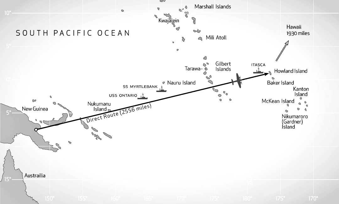
The above map shows a flight path from Lae direct
to Howland Island - 2,221 nautical miles (2,556 statute miles) (4,113
km.) - on a heading of 78° (degrees) (true north).
A compass
indicates the direction to the magnetic north pole, which changes position, rather than the geographic north pole, and is
influenced by local variations in the earth's magnetic field. Two variations along the flight path would require
the pilot to steer the plane on two different magnetic bearings to maintain true heading and stay on course.
Noonan's
chart is not available. Before departure, he may have plotted diversions from a direct path to avoid the forecast bad weather to the east
and perhaps also to take a bearing from the island of Nauru.
The actual
flight path may have been due east over the northern Solomon Islands; then northeast to Nukumanu or Luangiua
Atoll (Lord Howe Atoll) (Ontong Java Atoll); then northeast to within 35 to 50 nautical miles south of Nauru;
and then east to Howland. Memorandum Frederick J. Noonan April 29, 1935 Navigation on Pan Am Clipper Flights from Alameda, California to Honolulu,
Hawaii on April 16 - 17 and return on April 22 - 23, 1935. (Alameda
is on Oakland's southern border.) 3 pages
Finding Tiny Islands from Speeding Planes by Frederick Noonan The Sun, Baltimore, Maryland, March 22, 1936 Copy, paste and click to see:
Harry Balfour, radio operator for Guinea Airways in Lae in 1937
Lae to Howland - 2,221 nautical miles (nmi.) (nm.) (nm) Lae
to Nukumanu - 754 nm
It is assumed the radio operator for Guinea
Airways, Harry Balfour, maintained a radio log. One has never been made public. Chater and Callopy prepared their reports
after checking with Balfour. Their reports of three broadcasts, from 04:18 to 07:18 GMT (ET), are the only details of Earhart's
flight before Itasca radio operators reported hearing her at 14:15 GMT (ET). There are reasons to doubt the accuracy of Earhart's messages, or Balfour's account of them, or Chater's
report. Balfour may have panned his account. Chater may have erred in his report.
Earhart would broadcast hourly flight reports at 18 minutes past the hour
on 6210 kcs. during the day and 3105 kcs. at night. According to Chater the frequency in use at night was to be 3104
- an apparent mistake in reference to 3105.
Earhart would listen for Balfour on 6522 kcs. two minutes later, at 20
minutes past the hour. As noted previously, the use
of 6210 was restricted to the U. S. Earhart's receiver was calibrated or tuned to 6522 to receive Lae. Anyone anywhere listening might hear Earhart's broadcasts. As Earhart and Noonan took off (or shortly afterward), Balfour received a weather forecast by the US Navy
in Pearl Harbor, issued five hours earlier and relayed via the radio station in American Samoa. "Partly cloudy with dangerous local rain squalls about 300 miles east of Lae and scattered heavy showers
remainder of route." This was not good flying weather. Twenty-five-knot winds from east-south-east were forecast between Lae and
the Ontario. The winds would be twice the force predicted earlier. Twenty-knot winds from the east to east-north-east were forecast along the flight path from the Ontario
to Howland Island. The winds would be two to five knots stronger than predicted earlier. Lae
received also the latest weather forecasts from the island of Nauru, which read:
" . . . WIND EASTERLY 3 CLOUDY BUT FINE
CLOUDS CI CI STR CI CUMI MOVING FROM EASTERLY DIRECTION SEA SMOOTH . . NARU 8 AM UPPER AIR OBSERVATION 2000 FEET NINETY DEGREES
14 MPH 4000 FEET NINETY DEGREES 12 MPH 7500 FEET NINETY DEGREES 24 MPH."
Note: 8 a. m., July 2 on Nauru = 6:00 a. m. in Lae. The report
was four hours old.
CI = Cirrus, CI STR - Cirrostratus, CI CUMI = Cirrocumulus
The three cloud types are displayed in the top of the illustration below. They are called high clouds and
usually encountered between altitudes of 7,500 and 12,500 feet.
Cloud types
MPH = miles per hour.
Did
MPH mean miles per hour or nautical miles per hour? Statute miles per hour or knots? One would assume the Britishers on Nauru
would refer to knots rather than statute miles. But they could mention either. If statute miles, the speed of the wind
at 7,500 feet was about 21 knots, one knot faster than forecast by Pearl Harbor.
Thus,
from Lae to the Ontario: 25 knot winds. From the Ontario to Howland: 20-knot winds. Over Nauru: 24 mph (21-knot)
winds.
To reach Howland in 18 hours, Earhart would have to average a ground
speed of 123.4 knots over the entire course - or a true air speed of 148.4 knots from Lae to the Ontario
and 143.4 or 144.4 knots from the Ontario to Howland.
The recommended (optimum) true air speed of the plane for the best
fuel burn rate was 136.5 knots at lower altitudes and faster with a lighter load at higher altitudes.
To
fly against fast head winds, divert around a weather front, and fly within sight of Nauru, Earhart would have to fly a longer
distance and at a faster speed. This would consume more fuel.
Had
Earhart and Noonan known, before the take-off, would they have delayed the flight?
According to a radio telegraph message from Lae three weeks later, on 25 July, in reply to an enquiry about the flight,
Balfour relayed the latest weather forecasts from Honolulu and Nauru to Earhart three times -
at 10:22 a. m., Lae local time (00:22 GMT), 11:22 a.m. (01:22 GMT) and 12:22 p. m. (02:22 GMT).
According
to Chater, in his report, Balfour relayed the latest weather reports to Earhart by radio telephone eight times
- at twenty minutes past every hour until 5:20 p. m. Lae time (07:20 GMT) (07:20 ET). In a private letter 32
years later, in 1969, to the chief radioman on the Itasca during the Earhart's flight, Balfour repeated Chater: he sent the weather forecasts eight times.
Earhart did not acknowledge Balfour's weather reports. The rain squalls, heavy showers, strong head winds and quartering winds could delay the arrival on Howland to well after sunrise -
and without the stars as a guide.
Earhart and Noonan
would have to calculate again their fuel consumption and reserve. To abort the flight and return to Lae they would have to
dump fuel. In his letter in 1969, Balfour recalled that shortly after the take-off
he called Earhart (it can be assumed on 6522) and sent signals on 500 kcs. for her to test her RDF. This does not necessarily indicate that the failed test of the RDF in flight the day before was
on 500 kcs. Balfour
did not receive a response. Did Earhart receive his call? Her receiver was "calibrated" to 6522. Why not reply?
Apparently, that was typical of Earhart. Did she check the RDF? That would be the right thing to do. Earhart's ability - or inability
- to transmit and receive on 500 kcs. could determine the fate of the flight. Balfour did not hear or log Earhart's first four hourly broadcasts
- at 00:18, 01:18, 02:18 and 03:18 GMT. Apparently, he did not hear her until four hours and 18 minutes into the
flight. Balfour
reported only three messages from Earhart by radiotelephone, all on 6210 kcs.
Balfour thought local weather conditions interfered with reception
(Chater).
Given Earhart's poor health in the previous week and her problems
with radio, Noonan would have wisely joined Earhart
in the cockpit at broadcast times every hour - to ensure that she sent correct details and to
hear the radio messages from Lae himself. Whether or not he did this not is not known. It
was customary for a pilot to report with every message the plane's call sign, position (latitude first and longitude
second), altitude, speed, weather such as wind speed and direction and cloud formations, and Estimated Time of Arrival
(ETA) at destination.
First message (04:18
ET): Balfour (as reported by Chater): (04:18 GMT) 2:18 p.m. in Lae: Height 7,000 feet. Speed 140 knots. (Some remark about) Lae. Everything
okay. Where was the plane? Chater:
"The plane was called and asked to repeat position but we still could not get it." Callopy did not mention this first message in his letter. The
Electra was manufactured in the U. S. Did Earhart's cockpit instruments indicate nautical miles and/or statute miles? Reference
to nautical miles (knots), rather than statute miles and kilometres, is the standard in aviation throughout the world, including
the U. S. Instruments and pilots refer to nautical miles rather than statute miles or kilometres. However,
some old planes indicate statute miles and kilometres. Americans
writing about Amelia Earhart often refer to statute miles instead of nautical miles and "miles per hour" rather than "knots".
They convert knots to mph. Some have wondered if Earhart said "miles per hour" and Balfour noted the equivalent
in knots. If Earhart meant statute miles her speed was 121.7 knots. If Earhart said knots her speed was 161 statute m. p.
h. It is unlikely that Earhart referred to statute miles or said "miles per hour". In her telegrams she mentioned
"knots". Most assume Earhart said 140 knots. Most assume also that she meant her true air speed. Given the speed of the
forecast 25-knot quartering winds, her average ground speed was probably 115 knots. It is unlikely that she flew at 165 knots
true air speed. Second message (05:19 ET): Balfour
(as reported by Callopy): "At about three p.m. a message came through to
the effect that they were at 10,000 feet but were going to reduce altitude because of
thick banks of cumulus clouds." (Lae time.) Balfour
(Chater): (05:19 GMT) 3:19 p. m. in Lae: Height 10,000 feet. Position 150.7 East 7.3 South. Cumulus clouds. Everything okay. Latitude
should have been reported first and longitude second. Earhart probably said "One
Five Nought (or Naught) Degrees Seven Minutes East", which is 150 degrees (°), 7 minutes (') East
(E), and "Seven Degrees Three Minutes South", which is - 7 degrees (°), 3 minutes (') South (S), which is noted
as 150° 7' E - 7° 3' S. Either - (minus sign) or S denotes South. Either + (plus sign) or N denotes North.
Cumulus clouds seen from below.
Cumulus clouds seen from above. This
position is 187 nautical miles east of Lae and over the Solomon Sea, 48 nm. south of the island of New Britain and 55 n. m.
south of a straight flight path from Lae to Howland. Some have wondered about the stop (.) in Balfour's
notation. Was it a decimal point? Noonan always referred to degrees and
minutes. As far as is known, Balfour did too. He did not note decimal degrees. However, in noting coordinates he may
have written the stop (.) instead of the degree symbol (°) between degrees and minutes.
A degree is divided into 60 minutes. If Balfour's notation was a decimal point, Earhart's
position was 150 degrees 42 minutes East and 7 degrees 18 minutes South (150° 42' E 7° 18' S) - 40
nautical miles farther to the east-south-east and 225 nautical miles from Lae on a more southerly heading of 98 to 99 degrees.
It is generally agreed that Earhart's reported position at 05:19 GMT (the second
message, as reported by Chater) was incorrectly reported or logged or Chater's report in error. After five hours and 19 minutes
in the air, Earhart was only 187 (or 225) nautical miles out from Lae for an average ground speed of only 35 (or
42) knots. Earhart could not have said "Everything okay". It
has been suggested that the position reported at 05:19 GMT was a noon position report, a standard maritime procedure, for
12:00 noon in Lae (02:00 GMT). On Pan Am's Clipper flights across the Pacific, Noonan took noon positions and it became the practice at
Pan Am.
No
doubt, Noonan took a noon position. He probably projected the plane's position 18 minutes hence and Earhart reported the projected
position in her scheduled broadcast 18 minutes later,
at 02:18 GMT (12:18 p. m. in Lae) - a message not heard or logged by Balfour. A
position reported three hours late seems unlikely. Its report instead of the current or latest position is also unlikely. If,
however, the report was for a position at 12 noon the plane covered the distance in two hours for an
average ground speed of 93.5 or 112.5 knots.
In
any case, it is most unlikely that Earhart would climb to 10,000 feet in two hours - much faster
than the recommended rate of climb for the plane in the given conditions. However, Earhart could have been at 10,000 feet
at 05:00 (05:19) GMT. It has been suggested that Earhart's reported position at 05:19 GMT was
actually 157.0 East Longitude ("One Five Seven Degrees Nought Minutes") instead of the reported or logged 150.7.
This might make more sense, placing the plane over the centre of Choiseul Island, one of the northern British Solomon Islands
(and southeast of Bougainville Island), and about 600 nautical miles east of Lae for an average ground speed of 113 knots.
This position would indicate strong headwinds and a detour to the south
to go around bad weather. It would indicate also that Earhart was well behind schedule. If there was a time to turn back,
this was it. The plane could make it to Lae by sunset. Balfour
did not log Earhart's next scheduled hourly broadcast at 06:18 GMT. Nukumanu Islands Satellite photo of the Nukumanu Islands.
Third and last message (07:18 ET): Balfour
(Callopy): "The next and last message was to the effect that they were at 7,000 feet and making 150 knots, this message
was received at approx. 5 p.m." (Lae time.) Balfour
(Chater): (07:18 GMT) 5:18 p. m. in Lae: Position 4.33 South 159.7 East. Height 8,000 feet over cumulus clouds. Wind 23 knots. Earhart
probably said "Four Degrees Thirty-Three Minutes South", which is South Latitude 4 degrees 33 minutes ( - 4° 33' S), and "One Five
Nine Degrees Seven Minutes East", which is East Longitude 159 degrees, 7 minutes (159° 7' E). Earhart and
Noonan were 11 nautical miles due west of Nukumanu Atoll's western shores. A
degree is divided into 60 minutes and a minute is divided into 60 seconds. If Balfour's notation was
a decimal point, Earhart's position was 4 degrees, 19 minutes, 48 seconds South and 159 degrees, 42 minutes East (4.33° S
159.7° E = 4° 19' 48" S 159° 42' E) - about 25 nautical miles northeast by east off the northern tip
of the atoll. The two positions are 40 to 50 nautical miles apart southwest -northeast.
Nukumanu is about 25 nautical miles north of Luangiua Atoll (Lord Howe
Atoll) (Ontong Java Atoll), one of the largest atolls in the Pacific. Flying at
7,000 or 8,000 feet and "over cumulus clouds" could Earhart and Noonan see Nukumanu and Luangiua? If not, Noonan calculated
their position by celestial navigation and dead reckoning - the setting sun (before twilight), the
speed of the plane and speed and direction of the wind. However, Noonan would have preferred sighting the atoll for a
more positive position fix. Earhart and Noonan were on the direct flight path from Lae to Howland. They had flown about one-third of the course. But
at 7:18 GMT they were at least an hour behind schedule. Thus, some maintain that Earhart could not possibly have been over
Nukumanu at the reported time but passed the island at least an hour earlier, probably at 06:00 GMT (4:00 p. m. in Lae), which
would give her a more reasonable average ground speed of 125 knots. Otherwise, she would have turned back to Lae long
before. If Earhart flew over Nukumanu at 06:00 GMT, she would have reported it
in her 06:18 GMT broadcast and not at 07:18 GMT. It is often suggested that the plane reached this position 18 minutes earlier,
on the hour, at 07:00 GMT, because its report was delayed until the scheduled broadcast at 07:18 GMT. It
is assumed that the navigator would need about 18 minutes to calculate the position. Thus, it has been suggested also that
Earhart reached Nukumanu some forty minutes earlier. But Earhart's reported positions may have been based on projections by
Noonan. During the fight from Oakland to Honolulu in March, Noonan gave the
cockpit projected positions based on his charts plotted before the flight and his estimates from celestial navigation, dead
reckoning and Manning's radio navigation on board. One position was projected 40 minutes before Earhart's scheduled broadcast.
Balfour's two position reports are the only ones for the entire flight
from Lae to Howland. However, their accuracy - validity - has been questioned.
Only the second position report makes sense. How the plane got to Nukumanu is not known. Where it flew between
Lae and Nukumanu is not known. How it avoided the bad weather 300 miles east of Lae is not known. It is assumed the plane
flew south of it. How far to the south is not known. How broad was the weather front? The
last two messages heard by Balfour - at 3:19 p. m. (05:19 GMT) and 5:18 p. m. (07:18 GMT)
- reported Earhart's position. The last reported position, at 07:18 GMT, near Nukumanu, is some 560 nautical
miles from the previous reported position, at 05:19 GMT. The two reports were two hours apart and indicate an impossible average
ground speed of 280 knots. Thus, the exact positions and their times must be questioned. If,
as some suggest, the position reported at 05:19 GMT (the second message) was actually for 12:00 noon in Lae
- 02:00 GMT - and the last report at 07:18 GMT (the third message) was a position report
for 07:00 GMT, the average ground speed over the distance covered in five hours was about 112 knots. If
Earhart was over Choiseul Island at 05:19 GMT (or 05:00 GMT) and Nukumanu at 07:18 GMT (or 07:00 GMT), she flew about 200
nautical miles in two hours for an average ground speed of 100 knots. Before
departing Lae, Earhart and Noonan planned for a possible turn-around if at some point they were uncertain of reaching Howland.
The weather might be too bad. They might not have enough fuel.
Earhart had to average a ground speed of 123.4 knots to reach Howland in 18
hours from Lae. Nukumanu is about 750 nautical miles (860 statute miles) on a direct path from Lae. Earhart took more than
seven hours to reach it. Her average ground speed point to point was 102.5 nautical miles per hour. At
this rate, the flight from Lae to Howland could take more than 21 hours and exhaust the plane's reserve fuel. Earhart would
have to fare better or return to Lae, for a night-landing, or head for the nearest airfield, near Rabaul. The
delayed schedule was most likely due to strong headwinds and a longer, indirect flight path around bad weather. Could they make up for
lost time?
Nukumanu
Atoll is about 1,470 nautical miles from Howland Island. To reach Howland in 18 hours - 20 minutes
after sunrise (sunrise at 17:40 GMT) - the plane would have to average a ground speed of about 137.5
knots over the rest of the path.
Many point out that if Chater's and Callopy's reports were accurate, and Earhart was flying
at a true air speed of 150 knots against 23-knot-winds, her average ground speed was 127 knots over Nukumanu.
The latest forecast was for 25-knot
winds from Lae to the Ontario and for 20-knot winds from the Ontario to Howland. The reported winds over
Nauru were 21 knots.
With 20
to 25-knot headwinds and quartering winds, to average a ground speed of 137.5 knots Earhart would have to fly at a true air
speed of 157.5 to 162.5 knots to reach Howland in 18 hours. This would consume more fuel. If Earhart maintained
a true air speed of 150 knots and flew against 25-knot winds the rest of the way she could arrive by 19:00 GMT (ET).
Earhart mentioned the speed of the winds, an estimate derived
from dead reckoning, but not their direction. It can be assumed the wind was, as forecast, a crosswind or quartering
wind from east-south-east. Not a headwind (or tailwind).
Calculating
the affect of winds on a plane's speed, course and heading is complicated and Noonan would have to check with Earhart often
to correct drift to keep the plane on course. From Nukumanu, Earhart and Noonan headed into the night. Balfour
did not hear Earhart again. As planned, Earhart probably changed radio frequencies from the day-time 6210 kcs. to "3104" kcs.
(Chater) for the night. Balfour listened for three hours on both frequencies but heard nothing. In his report, Chater mentioned
3104 kcs. rather than 3105. Chater: "Miss Earhart had arranged to change to 3104 KC wave length at
dusk, but signals were very strong and the plane was then called and asked not to change to 3104 KC yet as her signals were
getting stronger and we should have no trouble holding signals for a long time to come. We received no reply to this call
although the Operator listened for three hours after that on an 8-valve super-heterodyne Short Wave Receiver and both wave
lengths were searched." Callopy: "Balfour stated that they advised him they would change the wave
length at nightfall. Balfour advised them just before nightfall not to change as their signals were coming through quite strong.
They apparently changed however as Balfour never heard them again." It
appears that Balfour missed a total of five scheduled hourly radio broadcasts by Earhart before 07:18 GMT and three broadcasts
afterwards. It is not known if Earhart heard any of Balfour's messages. From
Earhart's eight messages over the course of seven hours, as reported by Chater, Balfour logged only three. The messages
included two position reports; two reports of the plane's speed; one report of wind speed; three reports of altitude; and two
reports of cumulus clouds. The times and coordinates of both position reports have been questioned. One reported
position cannot be correct. On the earlier first attempt of the World Flight, from Oakland to Honolulu,
Manning, the radio operator on board, contacted various radio stations. Had radio equipment been in the cabin, Noonan
would have done so too. It is not known if Earhart contacted - or tried to contact
- anyone en route besides Lae, the Ontario and the Itasca. It is believed that Earhart burned about ten percent extra fuel (about 100 gallons
of fuel or half her reserve) in a long detour to avoid bad weather and in flying against strong winds much of the flight.
The USS Ontario, MV Myrtlebank
and Nauru Lae to Nukumanu - 754 nautical miles Nukumanu to Howland - 1,471 nm Lae to USS Ontario - 1,115 nm Nukumanu to USS Ontario - 365 nm USS Ontario to Howland - 1,106 nm USS Ontario to IDL - 903 nm Nukumanu to Nauru - 510 nm Nauru to Howland - 990 nm Nauru
to IDL - 787 nm About half-way along the flight path to Howland, the picket ship, USS Ontario (AT-13), was
to signal the flyers. The Ontario was a US Navy tug boat based in American Samoa where she served as the governor's
yacht. The ship waited for Earhart at the same point in March. The Ontario had been on station a fortnight, since
mid-June, waiting for Earhart again. The ship was running out of coal and would have to head back to Samoa as soon as possible.
On the night of 2 July the Ontario was several miles north
of the planned flight path. According to the weather forecast from Honolulu,
issued 15 hours earlier, Earhart and Noonan were to encounter 25-knot
winds from east-south-east between Nukumanu and the Ontario. If
they maintained their heading of 78 degrees (true) from Lae to Howland they were buffeted by strong quartering winds across
their starboard side. They would
be blown to the north. They would have to change their heading often to correct drift and stay on course. The Ontario
was about 365 nautical miles east of Nukumanu. If Earhart and Noonan saw Nukumanu at 07:18 GMT, flew at a true air speed of
150 knots against a 23 or 25-knot wind, they would sight the Ontario less than three hours later, around 10:12 GMT.
Initially, Earhart planned
to contact the Ontario when approaching mid-point of the flight path. The Ontario radio operator
was to respond with signals for Earhart's RDF to find the ship's direction and position. Noonan would thus know how best
to proceed to Howland. The
radio capabilities of the Ontario were limited. The ships's radio could send and receive radio messages by telegraph
on low frequencies ranging from 195 to 600 kcs. Earhart
would have to contact the ship by Morse Code on a low frequency. Then she would try to get a bearing on the ship's signals
with her RDF. The Ontario stood
by on 400 kcs. While on Java, Earhart agreed to this frequency. Earhart would contact the ship on 400 kcs. Then the ship would broadcast the letter "N" in Morse Code for five minutes and repeat the ship's call
letters twice at the end of every minute. Earhart would take a bearing on the ship's signals with her RDF. Initially,
it was suggested the Itasca, at Howland, could stand by on the same or a similar low frequency. In her
instructions to the Itasca, Earhart changed the frequency 400 kcs. - wavelength 750 metres
- to 7500 kcs. For the Ontario, Earhart did not change the suggested frequency of 400 kcs. because she
knew the ship did not have high frequency. The
Itasca did. Balfour
checked Earhart's radio receiver on 500 kcs. in Lae. Apparently, it worked. Earlier, Putnam warned that Earhart's receiver
on 500 kcs. was of "dubious usability". That is to say, the receiver was unlikely to work on that frequency. It was unlikely
to receive signals on 500 kcs. It might not work on other low frequencies, like 400 kcs. It appears that the same applied
to the transmitter.
If Putnam was correct, Earhart would be
unable to contact or hear the ship or take a bearing.
It appears that Earhart never
intended to contact the Ontario. The day before her departure from Lae, she changed her instructions. She would not
contact the ship. Instead, the Ontario was to transmit on 400 kcs. at ten past every hour the letter
"N" in Morse Code for five minutes, with the ship's call letters twice at the end of each minute. Earhart was too late. There is no evidence that her telegram, on 1 July, which would have
to be relayed by another station, in American Samoa, reached
the Ontario in time. Earhart knew that there was little chance that it would. The Ontario waited for Earhart's call. The Ontario
did not report radio contact with the plane. The ship's logs for 2 July do not mention Earhart or a plane. No one aboard the ship reported seeing or hearing a plane. Apparently, the ship's radio could receive (but not transmit)
on 3000 kcs. Earhart had been informed. Earhart could not contact the ship on 3105 kcs. but she might try on 3000 kcs.
She could transmit also a Morse Code signal on 500 kcs. to call
the ship. Evidently, she preferred not to. Or she could not. She did not call the ship on 400 kcs. or 500 kcs. or 3000 kcs.
During the flight, the Itasca,
stationed off Howland, asked the Ontario if the ship had heard Earhart. The reply was negative. According to an archivist of the National Archives, the
Ontario logs for June and July 1937 do not mention Earhart at all. On the following day, 3 July, at 10:30 GMT - after the flight
- the Itasca received a message from the radio station on the island of Nauru,
relayed by the radio station KPH Radio Marine Corporation of America (RCA) in Bolinas, California to US Coast
Guard headquarters in San Francisco. According to this message, Nauru heard unintelligible radio messages from Earhart during
the flight the night before - on 2 July - with the hum of the plane in
the background. No specific times
were mentioned. According to this message, Nauru never heard an intelligible message from Earhart.
There was another report, shortly after
the Coast Guard message, also on 3 July, from another source, that the radio operator on Nauru actually heard an intelligible message
from Earhart during the flight, at 10:30 GMT on the previous day, 2 July. This report was at 12:00 GMT on 3
July by the American consul in Sydney, Australia, Alfred Doyle, in a telegram to the State Department in Washington D. C. Doyle reported that Amalgamated Wireless in Sydney had just "received" "information" about Earhart's flight on the previous night. According to Doyle, this "information" had just been sent by the radio operator on Nauru to the radio station KPH RCA in Bolinas for relay to Coast
Guard HQ in San Francisco. According
to Doyle, one part of the message (the second part) from Nauru to Bolinas read: Message from plane when at least 60 miles
south of Nauru received 8:30 PM Sydney time July 2nd saying "a ship in sight ahead". Since identified as steamer Myrtle
Bank which arrived Nauru daybreak today. Reported no contact between Itasca and Nauru radio.
8:30 PM Sydney time, 2 July (same as Nauru) = 10:30 GMT 2 July. This
reported ship-sighting message must be viewed with some scepticism. It is not the message the Itasca received from
Nauru, relayed by RCA and Coast Guard HQ. The Itasca radio logs do not include such
a message. Nauru did not mention an intelligible message from Earhart. Doyle's telegram is the only
source of the claim that the Nauru radio station operator heard an intelligible message during the
flight - and the only source for the claim that Earhart saw a ship at 10:30 GMT on 2 July. It
was not reported by anyone else. (Much later, the State Department passed Doyle's telegram to the U. S. Navy.) A
Briton (or New Zealander), Harold J. Barnes, was in charge of the radio station on Nauru. The radio log is not available.
(It was claimed later that Barnes was absent at the time and an assistant worked the radio.) Doyle's
telegram, if its facts were accurate, is the only indication of Earhart's position at any time along the flight path
between Nukumanu and Howland. The purpose of Doyle's telegram, however, concerned another and later matter.
(See below.) The M. V. Myrtlebank was a British merchant ship en route from
New Zealand to Nauru to pick up a cargo of phosphate mined from bird excrement, better known by its Spanish name guano.
Guano was valued as fertilizer and mined on many Pacific islands in the 1800s. Nauru was still mined in the late
1900s. According
to the ship's log, at 10:30 GMT on 2 July the Myrtlebank was well to the north of Earhart's planned flight path,
perhaps by 30 miles, and about 110 to 115 nautical miles northeast of the Ontario, and about 105 nm. due south of
Nauru. The
Myrtlebank did not report radio contact with a plane. The ship's logs do not mention Earhart or a plane. No one aboard reported seeing or hearing a plane.
(Later claims to the contrary, made many decades later, must be doubted.) The Myrtlebank
was about 480 to 490 nautical miles east of Nukumanu. If Earhart was near Nukumanu at 07:18 GMT and saw the Myrtlebank at 10:30 GMT her average ground speed over 3 hours and 12
minutes was about 150
knots. Her true air speed was over 170 knots. A bit too fast.
If Earhart was near Nukumanu at 07:18 GMT and saw the Ontario at 10:30 GMT
her average ground speed from Nukumanu was just under 114 knots. Her true airspeed was just under 140 knots. Thus, she saw
the Ontario. Such estimates, however, are based on reports and forecasts. Reports are often approximate and conditions
are seldom constant. How far ahead of the plane was the ship when spotted or reported? Was the report at 07:18 GMT exact?
It
is possible that Earhart saw neither ship and saw
another ship. The message from Earhart might not have been in her exact words.
It is possible that Earhart did not see any ship at all. Noonan may have instructed Earhart to fly within
sight of Nauru for a better reference point. Noonan could not have had any illusions about Earhart's abilities to handle
pre-flight arrangements or the capabilities of her radios. Noonan knew beforehand, and was advised in Lae, that Nauru,
with its bright lights for night operations at its guano mining site, would offer a better bearing than the
Ontario. Earhart also was informed. Also, according to a radiogram from Rabaul to Lae, Nauru had
a "new fixed light" of "5,000 candle power" on a 560-ft. high tower - an ordinary beacon probably visible to
a plane thousands of feet up and at least 35 miles away. No one on Nauru reported
seeing or hearing a plane. Many have tried to calculate the plane's ETA on Howland
from this purported message from Nauru. At this point, if due south of
Nauru, the plane would be 990 to 1,000 nautical miles west of Howland. Twenty-knot winds were forecast
from the Ontario to Howland. Twenty-one-knot winds were reported over Nauru earlier. If Earhart and Noonan spotted the Myrtlebank or Nauru at 10:30 GMT and maintained an average ground
speed of 130 knots (150 to 151 knots true airspeed) they were about seven hours and 40 minutes from Howland. The
plane could sight the island by 18:10 GMT (ET) - one-half hour after sunrise on the island. Some insist Earhart could only have seen the Ontario,
at the half-way point, at 10:30 GMT. With an average
ground speed of 114 knots, the plane would not reach
Howland before 20:12 GMT. It might not have enough fuel. It would have to turn back to Lae. The plane would have turned back earlier. So, Earhart saw the Myrtlebank. However, if Earhart and Noonan could maintain
an average ground speed of 130 knots over the rest of their flight path from the Ontario -
1,110 to 1,115 nautical miles - they were eight hours and 40 minutes from Howland and could
sight the island around 19:10 GMT (ET) - 90 minutes after sunrise. Again, such estimates
are based on reports, which are often approximate. The weather can change. Could Earhart have mistaken
the Myrtlebank for the Ontario? Unlikely. The ships were more than 100 nautical miles apart. If Earhart mistook the Myrtlebank
for the Ontario, could
she pass
Howland and continue for an hour, expecting to sight the island more than 100 nautical miles farther to the east? Doyle's telegram, on 3 July, added that the Nauru radio operator heard unintelligible
messages from Earhart for four hours before her report of sighting a ship and for about one hour afterwards
- from 06:30 to 11:30 GMT. The Itasca did not receive such message from
Nauru (relayed from San Francisco). (See below.) Oddly, the ship-sighting message mentioned
by Doyle would be the only intelligible message Nauru
heard from Earhart. There is reason to doubt that Earhart saw the Myrtlebank. (See below.) The weather
about Nauru and the two ships was good, with light winds and clear visibility to the horizon all around. Parlly cloudy,
40 to 60%.
If
Earhart and Noonan flew within sight of Nauru and continued directly towards Howland they may have seen Ocean Island (Banaba
Island), 150 nautical miles to the east and 270 nautical miles west of the Gilbert
Islands. Wherever they were, Noonan had to be sure of the plane's fuel
supply and reaching Howland or returning safely to Lae. Turning
back at this point, Noonan might have to rely
on tailwinds to reach Lae before the end of the reserve fuel. The plane could reach Lae at dawn. The nearest landing fields along their flight track from
Lae were
near
Rabaul
on the island of New Britain and on the island of Bougainville. Night landings. There were no airfields on Nauru or Ocean
Island or the Gilbert Islands. It has been suggested that
with tailwinds the plane could still turn back after 12 hours on its flight path, probably at a point 100 nautical
miles west of the Gilberts. Beyond that point, the plane could not return to Lae. The
nearest landing field was on Howland Island.
Gilbert
Islands From
the Ontario to Howland Island, the forecast 20-knot winds were from
the east to east-north-east. From Nauru, 21-knot winds from the east. Earhart and Noonan would encounter
strong head winds and quartering winds on both sides of the plane on the flight path. There were no radio messages from Earhart about the Gilbert Islands.
There were radios on the islands of Beru and Tarawa. Neither reported hearing
Earhart. Neither had been informed of Earhart's flight. Exactly when and where Earhart and Noonan flew over the Gilbert Islands is not known. It was in the middle of the night, probably at an altitude of 7,000
to 8,000 feet. Some assume the plane, on a direct heading from Lae, flew over Tabiteuea Island, which is just below the
equator.
Howland Island Lae to Howland - 2,221 nautical miles Nikumanu
to Howland - 1,471 nm USS Ontario to Howland - 1,106 nm Nauru to Howland - 990 nm IDL to Howland - 203 nm
Howland Island
is the northernmost of the Phoenix Islands, which are between the Gilbert Islands to the west and the Line Islands to
the east.
Howland Island is a small
coral atoll 1.5 miles long (north to south) and 0.7
miles wide (east to west). Its highest point is ten to 15 feet above sea level. The
view in the above photo is from the southwest. The island was claimed by the U. S. in 1856, after British guano
miners abandoned it, and mined by American companies till 1878. The British claimed the island and mined it with Polynesian
workers from 1886 to 1891. The Americans and the British shared the island. The British still claimed the island in the 1930s. Because both Britain and the U. S. claimed the Phoenix
Islands, the U. S. felt it necessary to colonise Howland and other islands. Howland was considered also a possible mid-way refueling
stop for future Pan American Airways Clipper flights across the Pacific and
a possible military air base in the event of war with Japan. Thus, Howland was inhabited by a small colony of Hawaiians
from March 30, 1935 to January 31, 1942. Construction of three airstrips began in 1936 and completed in early 1937,
in time for Earhart's anticipated arrival from Hawaii on 21 March. The airfield was a Works Progress Administration (WPA) project. The WPA was created in 1935 to give Americans employment
during the Depression. Projects included constructing roads, bridges, housing, airports, etc. (Germany had a similar
program.) Earhart donated $2,000 for the construction of the airstrips. There was one long north-south runway and two short runways, east-west and northeast-southwest.
The airfield was
named Kamakaiwi Field for the Hawaiian leader of the colony, James Kamakaiwi. Many islands in the Pacific were incorrectly charted. On Earhart's chart (or one she is thought to have used)
Howland Island was six nautical miles to the west of its actual position. The Coast Guard complained that the incorrect charting
posed a navigational hazard to ships. Whether or not Noonan relied on Earhart's chart is not known. He may have made more accurate
and up-to-date charts from recent surveys by the Coast Guard. Noonan and Earhart could have gotten the latest details in Hawaii
in March 1937 or in California later.
1937 photo of a 20-foot tall light house on Kamakaiwi Field on Howland Island, completed in late 1937. At
the time of Earhart's flight, it was without a lamp and served as a day beacon. It was bombed by the Japanese on 8 December
1941, the day after the Japanese attack on Pearl Harbor on Oahu. The partially restored day beacon is known today as Earhart
Light. USCGC Itasca Undated photo of the USCGC Itasca
(not taken on Howland). The Coast Guard sent a ship every three months on an expedition
to resupply the US Equatorial Islands, including Howland, Baker and Jarvis. Along the equator lie the U. S. Equatorial
Islands of Howland, Baker and Jarvis. Baker is 42 miles southeast of Howland.
Jarvis is one of the Line Islands and about 1,000 nautical
miles to the east of Howland and Baker. Jarvis is just south of the equator. Howland and Baker are just north of the equator.
The U. S. Coast Guard Cutter Itasca brought the first Hawaiian
colonists to Howland. From 1935 to 1940, the Itasca, based in San Diego, California, sailed often
to Howland and the Hawaiian colony lived on the west shore of the Island in Itasca Town.
Under a Jarvis
Moon
Documentary on the
program Pacific Heartbeat
Preview
About the documentary
Documentary (56:49) or Hui Panalaau
Under a Jarvis Moon
Song
Kamehameha Alumni Glee Club
3 October 2015
Sketch of Howland Island as it was in 1937. The
Itasca, commanded by USCG Commander Warner
Thompson, was stationed at Howland Island. (The rank of commander in the U. S. Navy and U. S. Coast Guard is equivalent to
the rank of lieutenant colonel in the U. S. Army and Marines.) Thompson was on his first cruise to Howland. The ship lay five miles off the island's lee
(west) shore and
drifted to the west. On this occasion, the Itasca
was at Howland for the additional purpose of assisting Earhart's flight. The ship would lay black smoke
early during the day. Search lights for a night landing. The ship brought fuel, spare parts and mechanics. Fire-fighting equipment in case of an accident on landing or take-off. The
Itasca was to rescue the flyers if they went down at sea and search for them if necessary. As mentioned
previously, Richard Black was responsible for all arrangements on the Itasca
and Howland and along the flight path for Earhart's flight across the Pacific from Lae to Hawaii. Black was the Putnams'
personal contact and representative on the Itasca and Howland. Black was
also the leader of the expedition to Howland. Black, a civil engineer, was the local field representative of the Department
of Interior, which had responsibility for the US Equatorial Islands, including Howland, Baker and Jarvis. Black was responsible
for their administration. He was on his fifth cruise to the islands. Terns on Howland Island Howland Island, like many Pacific islands, was home to tens of thousands
of albatrosses, boobies, frigates and terns. Earhart was warned that the birds could pose a hazard to a plane. A bird
hitting a propeller can knock out an engine. Just before Earhart's flight, the crew of the Itasca slaughtered many
birds on the island in an attempt to reduce their presence. Dynamite was blasted in an effort to force the birds to the north
end of the island. Noonan was to navigate the plane to Howland - if not directly
to the island, then close to it. Like the Ontario, the Itasca
was to serve as a radio beacon for Earhart as the plane approached Howland. Earhart
could take bearings on radio signals from the ship to be sure of the direction to the island. The Itasca had better radio equipment than the Ontario.
As agreed before the flight, Earhart
and the Itasca would transmit and receive messages by
voice over the radio telephone on 3105 at night and 6210 during the day. The Itasca would transmit
messages in Morse Code by telegraph on 7500. The Itasca had four 200-watt (?) radio transmitters - two for low frequencies, calibrated
for 425 and 500 kcs., and two for high frequencies, calibrated for 3105, 6210 and 7500 kcs, the first three frequencies for
voice and Morse key. However, voice could be transmitted on 6210 and 7500. The Itasca had many receivers and could
receive on all frequencies. As
noted previously, on the ill-fated first attempt of the World Flight, in March, on the first leg, from California to Honolulu,
the plane transmitted on 3105 by day and 6210 by night. Manning took a bearing from a radio beacon near Honolulu on signals
on 290 kcs. For the flight from Honolulu, on the approach to Howland, Manning would take a bearing on low-frequency signals
from the Coast Guard cutter on plane guard at the time, the Shoshone. Thus, for the second attempt, as Earhart approached
the island from Lae, the Itasca would transmit low-frequency signals in Morse Code. Earhart's RDF could take a bearing on the signals to know the
ship's direction. In telegrams, Earhart indicated her radio could transmit and receive on 500 kcs. Balfour in Lae said the receiver
worked on 500. Putnam
specified that the range of Earhart's RDF was "about" 200 to 1400. The Itasca was informed
also of Putnam's warning that Earhart's radio on 500 kcs. was of "dubious usability". She might not be able to transmit or
receive on 500. Whether or not that was so is not certain. The Itasca sent signals in Morse on 500 several times during the last
hour of the flight. Whether or not Earhart received them or tried to take a bearing on them is not known. There is no indication
that she did. If Earhart
could not receive on 500, as Putnam warned, she might not be able to receive other low frequencies. That would leave her with
only high-frequency capability. Cmdr. Thompson pointed out that an RDF could not take bearings on signals higher than 1500 kcs. If the range of Earhart's RDF was 200 to 1400 - but Earhart could not take a bearing on 500
kcs. or other low requencies - there was only a chance that she might take a bearing on the ship's
signals on 3105 when close to the ship and
the signals strong enough. At the end of June, Earhart claimed that her RDF's range was 200 to 1500 and 2400 to 4800. ("Any frequency not near ends of bands
suitable.") If Earhart actually had a high-frequency RDF with a range of 2400 to 4800 kcs, as she claimed,
she could take a bearing on signals on 3105.
There were "experimental" high-frequency
RDFs. Perhaps Earhart had one. Cmdr. Thompson accepted Earhart's specification
of 2400 to 4800. Earhart asked the Itasca
to transmit every half-hour on the hour on 7500 kcs. the letter "A" in Morse Code for five minutes with the ship's position
and call letters repeated twice at the end of every minute. Did Earhart intend to take bearings on 7500? Cmdr. Thompson pointed out that, as far as was known,
RDFs could not take bearings on signals on 7500. In any case, the Itasca transmitted in voice and Morse on 3105 and in Morse on 7500 throughout
the flight. Scheduled messages with weather reports on 7500 in Morse and occasionally with
voice on 3105. Most transmissions were with voice on 3105. As mentioned above, before departing Lae, Earhart asked the Itasca to transmit a long
continuous tone on 3105 as she approached Howland. Evidently, she would try to take a bearing on 3105. In the event, the Itasca
never transmitted a long continuous tone on 3105 for Earhart at any time. However, the ship occasionally repeated the
letter "A" with its call sign and position in Morse on 3105 for several minutes at irregular and unscheduled times.
Did
Earhart ever hear the Itasca? There is no indication that she heard the Itasca on 500 or 3105. Earhart acknowledged
hearing the Itasca only twice. According to the radio logs she heard signals on 7500 kcs. This was questioned. The Itasca received numerous messages from
Earhart on 3105 only. The Itasca
eventually listened for Earhart on 7500. This could indicate that Earhart could transmit on 7500. If so, her transmitter's
third band could be tuned or the transmitter had a fouth or fifth or sixth band. The Itasca
had an RDF. When
Earhart drew close to the island the RDF aboard could take a bearing on a signal or signals from the plane and direct
Earhart to the island. The
suggestion that the ship's RDF should take bearings on Earhart seems to have upset Thompson. It had not been foreseen, he
claimed, that the Itasca would take bearings on Earhart. The Itasca RDF could not take bearings on frequencies above
550 kcs. Earhart was informed. As Earhart approached the island, she could transmit signals in Morse or voice
or a long tone on 500 kcs. If, however, her transmitter could not function on 500 kcs., as Putnam indicated,
the Itasca could not guide her to the island. In the event, the Itasca RDF never heard Earhart on 500 kcs. Apparently,
Earhart never transmitted on 500. Thus, the
Itasca never got a bearing on Earhart. The Itasca received messages from Earhart only in voice
by radio telephone on 3105. She was never heard on 500, 6210 or 7500. She never transmitted a message by telegraph. She did
not have one. She never transmitted a long tone. After
Earhart's last radio message, the Itasca listened for her also on 6210. The radio logs do not indicate that the Itasca
ever transmitted on 6210 during the flight. Pan American Airways installed an Adcock high-frequency RDF system on
Oahu, Midway and Wake Islands in 1935 to assist its Clipper flights across the Pacific. Pan Am assisted Earhart
on her flight from Oakland to Honolulu in March 1937. Pan Am's RDF on Oahu took bearings on signals (long dashes) on
3105 from the plane, sent by Manning, from a long distance, and radioed back the plane's position to Manning,
on 2986 kcs. in Morse
Code at the slow rate of two words per minute. See Electronics, April 1936: Pan Am was not expected to assist
the flight between Lae and Howland. As far as is known, Pan Am's RDFs did not track the flight. Before the first
attempt, in March, Manning and a top government official requested a high-frequency RDF for Howland. The request was too late.
The ship to Howland had sailed. Before the second attempt, another request
was made. Who requested it is unclear. According to Coast Guard
telegrams, the "plane" - Earhart or Noonan or both (or Earhart's or Putnam's associates in government)
- requested an HF RDF on Howland. Some believe Black suggested it.
According to some accounts,
Paul Mantz learned of an unused RDF in Honolulu. According to other accounts, Black procured the RDF from the Navy. Accompanying Richard Black on the cruise was a US Army Air Corps pilot, 1st. Lt. Daniel Cooper,
who was to inspect final perparations of the airstrips. Cooper was on the cruise also
as an observer. Black and Cooper arranged
with the Navy and Coast Guard to send the Navy HF RDF to Howland. Details of this "Navy HF RDF" are not
clear. It was "borrowed" from a navy patrol plane in Pearl Harbor. It has been described as a "small portable airplane-type"
"one-watt" (or less) "experimental" "high-frequency" RDF with a loop antenna. It may have been a "military version". It may
have been a "twin" of Earhart's RDF. Its range of frequencies is not clear but, if high-frequency, probably not higher
than 4800 kcs. As mentioned
previously, a small loop antenna was never developed to take bearings above 1800 kcs. It could - or it could
not - detect the source of a radio signal directly like a radio compass. Indications are that it detected
only the baseline of signals.
Bendix portable RDF with rotatable loop antenna c. 1940 Black and Cooper brought the Navy HF RDF and a Coast Guard radioman 2nd class, Frank Cipriani,
detached from a cutter in dry dock, the USCGC Taney, to the Itasca. Cmdr. Thompson would not "receipt" for the Navy
HF RDF. The Coast Guard had not requested it. He doubted it would work. He considered it unreliable and unlikely
to assist Earhart to the island. He would not allow for its use on board. It could only get in the way of his ship's operations. Thompson suggested
Cipriani set up the HF RDF on Howland as a precaution in case of an emergency. All this, however, seems to have been
decided beforehand. The
placement of an HF RDF was announced in the press in June. The
Itasca reached Howland on 24 June. According to a telegram from the Itasca to Coast Guard HQ on 28
June, the HF RDF was in place on Howland. There were claims that Earhart was unaware of the HF RDF on Howland. It has been suggested that, if true,
this was because the HF RDF was not expected to work and its presence on Howland just for show. There
was no mention of the RDF on Howland in telegrams "from the Itasca" to Earhart. Thompson did not mention it. Black,
who sent and relayed messages to and from the Putnams, mentioned the Itasca RDF to Earhart but not the HF RDF on
Howland. It has been assumed that Putnam informed Earhart by telephone. According
to Putnam, their last telelphone conversation was on 25 June when Putnam was in Oakland and Earhart on Java. Some wonder if Earhart hoped an Adcock HF RDF system would be on Howland in time for her flight. That is
unlikely. Pan Am eventually installed an RDF in the Phoenix Islands, on Kanton (Canton)
Island, to assist its Clipper flights across the South Pacific, but not on Howland. Some on board the Itasca may
have assumed the Navy
HF RDF was a very large and heavy device. It was not. If
Putnam informed Earhart of the HF RDF she may have wondered about the telegrams from Black and the Itasca. An HF
RDF not worth mentioning is no HF RDF at all.
Could this have led to second thoughts about the flight? In telegrams, Earhart specified that she had 500 kcs. If so, there should not be any problems as
she drew near the island. Earhart knew the limitations of the Itasca RDF. It could not take bearings
above 550 kcs. If Earhart's 500 was in fact of "dubious usability" and she could not take bearings on low-frequency signals,
the HF RDF on Howland was essential. It would have to take bearings on Earhart. Thus, she knew of the Navy HF RDF on Howland
and expected it to take bearings on her broadcasts on 3105. That was her only chance to reach Howland by radio. According
to Cooper, the Navy HF RDF could take a bearing on 3105 but it was to be set up on Howland just as a precautionary emergency measure, in case the Itasca RDF, operating on 500
kcs., broke down. This remark may have been intended for Cmdr. Thompson.
By the end of June, it appeared definite that the HF RDF on Howland would
take bearings on the plane's broadcasts and relay its position to the Itasca. This was decided long before, however.
In the event, the Navy HF RDF proved of no value at all. Thompson, Black, Cooper and Cipriani neglected to make proper and
adequate preparations for the use of the Navy HF RDF on Howland. Black,
Cooper and Cipriani had more than a fortnight to prepare the HF RDF. According
to Cooper, however, the HF RDF was not calibrated before the flight and thus its readings were unreliable. Cipriani
turned on the HF RDF when Earhart was more than 1,000 miles from Howland. The HF RDF ran on gun batteries loaned by the Itasca.
Cipriani left it on all night and the batteries were almost dead by the time Earhart was expected to arrive. The HF RDF never got a bearing on Earhart. According
to Ciprinai's radio log, he caught Earhart's broadcast on 3105 on a long wire receiving antenna when the plane was about 200
miles from the island. He heard Earhart's messages but It is not certain that the HF RDF actually heard her
at any time. Cooper pointed out that bearings on signals on frequencies above 1500 kcs.
were generally unreliable beyond their optical range, especially in the morning (night effect).
Cipriani claimed Earhart never transmitted more than a few seconds at any time - not long
enough to get a bearing on her. Others seemed to agree. Cooper pointed out that a signal had to be several minutes long to
get a bearing on it. Earhart could transmit a long continuous tone but she never did so. Why? Her life might depend on it.
During the flight from Oakland to Honolulu in March, the right engine shut down temporarily. Just before, Manning
sent a long signal to the Pan Am Adcock HF RDF in Hawaii. It was thought possible that the long signal drained electrical
power and caused the engine to quit. Earhart might have feared another electrical failure if she transmitted a tone for a
minute or more. Over a vast and empty sea, this meant that Noonan would have to find Howland Island
on his own by celestial observations and dead reckoning. The moon and stars by night, the sun by day. Possible
only with a clear sky. Estimates of distance by time and speed, testing wind drift, and the most recent weather reports available
to him. Harry Balfour in Lae logged
one credible position report from Earhart earlier. But the Itasca radio operators never logged a precise position
report. The Itasca thought Earhart and Noonan were flying in poor weather and their ceiling
obscured. Noonan could not see the sun, moon and stars and calculate the plane's position.
Before the flight, Cmdr. Thompson told Coast Guard HQ in San Francisco that the ship's
radiomen had more work than they could handle. Earhart's flight - especially Black's messages and
press reports - had greatly increased radio traffic. On board were one chief radioman and three inexperienced
radiomen 3rd class. Thompson asked HQ for experienced radiomen 1st class. None was available. Black got from the Navy the experienced radiomen Thompson required. Thompson refused them. The Itasca was not a Navy ship. A photo of a radioman in the radio room of USCGC Tahoe,
sister ship of the Itasca, in the 1930s. The radio room was the same on both ships. USCG Itasca (Call sign: NRUI)
- Leo
Bellarts, Chief Radioman, USCG (DC) - Thomas O'Hare, Radioman 3rd Class, USCG (TO) - William
Galten, Radioman 3rd Class, USCG (BG) - George
Thompson, Radioman 3rd Class, USCG (Call sign: ?) Howland Island (Call sign: NRUI 2) - Frank Cipriani, Radioman 2nd Class, USCG Howland ham radio operators: - Yau
Fai Lum (Call sign: K6GNW) - Henry Lau (K6GAS) - Ah Kin Leong (K6ODC) Note that Yau Fai Lum is often confused with Paul Yat Lum, a ham radio operator stationed on Baker Island
at the time. Henry Lau and Paul Yat Lum boarded the Itasca in Honolulu. Paul Yat Lum got off on Baker
Island on 25 June. Ah Kin Leong, a ham radio operator,
left Baker on 25 June to transfer to Jarvis. Due to subsequent events, the Itasca could not make her scheduled call at
Jarvis.
There were two operators
in the ship's radio room at all times. They listened for Earhart through twin earphones
- to two frequencies at once, a different frequency in each
phone. Earhart was heard also over a loud
speaker in the radio room. The speaker was for any third frequency, as required, but
could be switched to any frequency.
Chief Radioman
Leo Bellarts and Radioman 3rd Class Thomas O’Hare were on the early morning watch in the radio room on 2 July. They manned radios at two positions, Position 1 and Position 2. Bellarts at Position 2 worked
Earhart's flight only. O'Hare at Position 1 handled
radio traffic with other stations but could listen in or hear Earhart's voice over the loud speaker when it was turned on.
Positions 1 and 2 kept separate radio logs. According to Cmdr. Thompson, the loud speaker was turned on just after
midnight, at 12:04 a. m. In an interview in 1973, Bellarts recalled that he turned the loud speaker off because it received
only loud static. He turned it on again several hours later. There are no audio recordings
of Earhart's messages by voice (or any signals in Morse Code) over the radio telephone. The operators did not necessarily
record her exact words as they logged her messages. Parts of some messages were not recorded. Some messages were not logged. The
original logs were a rough record of communications. The logs were edited later for presentation. However, the original log
for Position 2, kept by Bellarts and Galten, is available. The Itasca radiomen were unfamiliar
with aviation communication and may have made mistakes in logging Earhart's messages. Chief Radioman Bellarts was
a veteran radio operator with plane guard experience but he was not familar with aviation communication. The logs were "changed"
"here and there" later by Cmdr. Thompson, who also was unfamilar with aviation communication. As noted above, it was customary for a pilot to report with each message the
plane's position, altitude, speed and weather such as wind speed and cloud formations. In marked contrast to Harry Balfour's
reports (as reported by Chater and Callopy), the Itasca radio operators never logged a customary radio report from
Earhart. They never logged
a report of the speed of the plane or the wind. They logged the plane's altitude only once and a weather report only once. They logged two reports of the plane's approximate distance from Howland but without
coordinates. They never
logged a precise position report. According to the
logs, one operator requested position reports twice in the last twenty-three minutes of the flight. Not long afterward,
Earhart reported an apparent landfall but without coordinates. In his later Radio Transcripts, Cmdr. Thompson, citing "witnesses", claimed Earhart was asked her position
twice in the early morning hours after her first intelligible message was received. These position requests were not answered.
They were not logged. The loud speaker might not have been on yet. Many persons not directly involved in the ship's radio operations
visited the radio room. Some returned. Several
Army Air Corps pilots, including Cooper. Others were from the Navy. Some were
from the Department of Interior, including Black. Two press reporters, representing the Associated Press (AP) and
United Press (UP), had covered Earhart's flight in March. Before departing Lae, Earhart informed the Itasca that she
would broadcast every hour at quarter past the hour and perhaps also at quarter to the hour on 3105 kcs. She would listen
for the Itasca every half-hour on the hour. It has been pointed out that, according to the logs, the Itasca radio
operators did not always send messages on schedule and
also sent messages when they should have been listening instead. Howland Island was on Hawaii time, which was 10 1/2 hours behind GMT (00:00 GMT on 2 July minus
10 1/2 hours is 1:30 p. m. on 1 July). The Itasca was in a particular US Navy time zone, 11 1/2 hours behind GMT
(00:00 GMT on 2 July - 11:30 hours = 12:30 p. m. on 1 July). Howland was one hour ahead of the Itasca. The
radio operators on the Itasca referred to the US Navy time zone instead of GMT. The radio operators
on Howland referred to the Howland time zone. At
06:00 GMT, 2 July (6:30 p. m. on 1 July, Itasca time), Coast Guard HQ in San Francisco informed the Itasca
of a UP report that Earhart had taken off six hours earlier. Cipriani was sent ashore to man the Navy HF RDF. The Navy HF RDF on Howland was set up inside
a canvas tent at the airfield. Cipriani turned it on at 10:00 p. m. (Howland time) (9:00 p. m. Itasca time)
on 1 July (8:30 GMT, 2 July) (08:30 ET). The radio log available is not the original log but one prepared later by Cipriani
for presentation. Earhart's call sign was
KHAQQ (K-H-A-Q-Q).
A page from the original radio log of Position 2 in the radio room of the Itasca
with radio messages from 3:00 to 8:06 a. m. on 2 July (Itasca time) (14:30 - 19:36 GMT). Position 2 was manned
by Bellarts till 07:18 a. m. (18:48 GMT) and by Radioman 3rd Class Galten afterwards. Bellarts: (13:45 - 50 GMT) (ET) 02:15 - 02:20: Nothing heard on 3105.
Bellarts: (13:58 GMT) 02:28: Sent weather on 7500.
Note that all transmissions from the Itasca on 7500 were sent in Morse Code by telegraph.
O'Hare: (14:00 GMT) 02:30: Sending A's on 7500 kcs as per sked.
Note: The letter A was repeated in Morse Code.
Bellarts: (14:15 - 18 GMT) 02:45 - 48: Heard Earhart plane. But unreadable thru static.
O'Hare: (14:15 GMT) 02:45: Able hear Earhart at (on 3105).
Earhart was heard on her night-time frequency of 3105 kcs. Earhart's message was, as planned,
a half-hourly report at quarter past the hour GMT. This was the first sound of Earhart heard by the Itasca. If there was anything to Doyle's
telegram, this was also the first anyone heard Earhart since Nauru heard a last unintelligible message two hours and forty-five
minutes earlier, at 11:30 GMT (11:30 ET). In his Cruise Report,
an account of the expedition, Richard Black recalled that he reached the radio room at 3:45 a. m. He could have been in the
radio room for an hour or so before
sunrise.
One hour later: O'Hare:
(15:15 GMT) 03:45: Heard
Earhart plane on 3105. Bellarts: (15:15 GMT) 03:45: Earhart
heard fone. Will listen on hour and half on 3105 says she.
This was another scheduled hourly
or half-hourly report GMT. This was the first
intelligible message from Earhart heard by the Itasca. In his later report, Lt. Cooper recalled that he reached the radio toom at 3:46 a. m. There is no record of half-hourly broadcasts by Earhart at 15:45 GMT (4:15 Itasca
time) or 16:15 GMT (4:45 Itasca time).
One hour and eight minutes later: Bellarts: (16:23 GMT) 04:53: Sent weather
/ Code / fone / 3105 kcs. Heard Earhart. Part cloudy.
"Part cloudy" was erased and crossed out in the radio log. The line
below also was crossed out (and may have been erased before crossing out). "Part cloudy" appears to have been typed in at
a later time. In an interview in 1973, Bellarts recalled
that he made a mistake in crossing out the words and that Earhart did say "part cloudy". Black recalled that Earhart said "overcast". The radio logs do not mention "overcast".
In his Cruise Report, Cmdr. Thompson
recounted that "overcast" was heard over the radio room
loud speaker by witnesses. In 1973, Bellarts maintained that Earhart said "part cloudy"
- not "overcast". According to Bellarts, the loud speaker was not on at the
time and the persons who claimed Earhart said "overcast" could not have heard it. Thompson included
both accounts in his Cruise Report. If Earhart said "part cloudy", Noonan might make some observations of the stars and calculate the plane's
position. If Earhart said "overcast", the
ceiling was obscured and Noonan could not observe the stars. This was the only weather report from Earhart logged by the Itasca.
O'Hare: (16:25 GMT) 04:55: Earhart broke in on fone 3105. ???? Now unreadable.
There is no record of half-hourly broadcasts at 16:45 GMT (5:15 Itasca
time) or 17:15 GMT (5:45 Itasca time).
At sunrise on Howland - 6:10 a. m. (Itasca
time) (7:10 a. m. Howland time) (17:40 GMT) - a landing party headed for shore to wait for the plane.
The party included Black, Cooper, the two press men, the plane's maintenance crew and the ship's lieutenant
commander. It should be noted that most of the persons later quoted
as witnesses to events in the radio room left before sunrise or were not present after sunrise. They cited the radio logs
or passed on second and third-hand reports.
One hour and 17
minutes after Earhart's last message: O'Hare: (17:42 GMT) 06:12: Earhart on 3105 now. Wants bearing 3105. (17:43 GMT) 06:13: 200
miles out. Bellarts: (17:44 GMT) 06:14: Wants
bearing on 3105. On hour. Will whistle in mic. Bellarts: (17:45 GMT) 06:15: About 200 miles out. Approximately. Whistling. Now.
Earhart's message was a scheduled half-hourly
broadcast. The distance mentioned should be in nautical miles. Where
was the plane? Earhart's message was not a precise position report. She did not give coordinates.
Flying
over a vast and empty sea, how did Earhart know she was 200 miles out - or approximately 200 miles
from Howland?
A celestial navigator estimates his position on his flight path
by observations of the celestial sphere and by dead reckoning.
The navigator notes
the positions of the sun during the day and the moon, planets, stars and constellations at night. He consults nautical and
aeronautical almanacs. He applies trigonometry to obtain his coordinates from the positions of the stars. Fixes
from two or three stars give him his approximate position both north-south and east-west. An observation of the
sun gives him his approximate position east-west.
Dead reckoning (DR) (or
deduced reckoning, as it was later also called) is an estimate of one's position by a calculation of the distance flown over
the plane's track from a certain point - a recognisable geographical feature or a celestial fix
- and the time of the run with the plane's true air speed against the speed of the wind.
The dead reckoning run to this point could have been from Lae, Choiseul Island, Nukumanu Atoll, the Ontario,
Nauru, Ocean Island, one of the Gilbert Islands or the most recent star fix.
Noonan probably got a last position fix from two or three stars during the half-hour equatorial nautical
twilight 40 to 20 minutes before sunrise, probably between 17:10 and 17:30 GMT. He would know his approximate position and
could estimate where the plane would be at the time of Earhart's broadcast at quarter to the hour.
If 200 nautical
miles west of Howland, the plane was crossing the International Date Line (IDL) (180th Meridian, or Anti-Meridian) between
the Gilbert Islands and Howland Island. The plane was about 215 miles northeast of Arorae Island and 420 miles east of Tarawa.
By the local time zones below, the plane flew from the early morning of 3
July back into the morning of 2 July. If on a direct flight path from Lae, the plane was crossing also the equator.
Earhart and Noonan
had flown more than 90% of their course to Howland.
If Earhart and Noonan were 200 miles
out at 17:45 GMT (ET), they had flown 2,201 nautical miles in 17 3/4 hours for an average ground speed of about 114 knots. Flying
against 20 to 25-knot winds most of the track their true airspeed was 134
to 139 knots. However, the plane did not necessarily fly a straight path to this point.
If Earhart and Noonan saw Nukumanu at 07:18 GMT they
flew 1,268 nm in 10 hours and 25 minutes (or 10.4 hours) for an average ground speed of 122 knots (142 to 147 knots true air
speed).
If Earhart saw the Ontario at 10:30 GMT her
average ground speed at 17:43 - 45 GMT was 124 to 125 knots (144 to 150 knots true air speed).
If 200 miles out at 17:43 - 45 GMT, with an average
ground speed was about 125 knots, the plane should reach the island in 96 minutes, around 19:20 GMT.
If Earhart saw Nauru or the Myrtlebank at 10:30 GMT and crossed the IDL at 17:43
- 45 GMT the plane's average ground speed was 108 to 110 knots (128 to 135 knots true air speed). The plane could arrive
at Howland shortly after 19:30 GMT. If the plane was at 8,000
ft. the horizon was about 100 nm. ahead. Sunrise on Howland on 2 July 1937 was at 6:10 a. m. Itasca time) (17:40
GMT). If 200 miles out when Earhart broadcast at 17:43
and 17:45 GMT (6:13 and 6:15 a. m. Itasca time), the sun was rising over Howland
but not yet on the plane's horizon.
At the equator, the earth rotates
to the east at about 894 knots, or about 15 knots per minute. If about 200 nm. west of Howland at 17:43 -
45 GMT (6:13 - 15 a. m. Itasca time), at an altitude of 8,000 feet and flying at an average
ground speed of 125 knots, or 2.1 knots per minute, the sun would appear on the horizon ahead of the plane in five to six minutes, around 17:50 GMT (5:20 a. m. Itasca
time), ten minutes after sunrise on Howland. At 17:45 GMT, Earhart was viewing Civil Twilight ahead. In three to
four minutes, she would see a false sunrise - a refraction above the horizon of the sun's actual
position below the horizon.
The plane was late. The winds and a run around bad
weather had delayed it.
Without the stars to guide him, Noonan would
have only the sun to give him his latest position east-west. For his position north-south, he would have to rely on his last
star fix during nautical twilight.
An entry in the ship's deck log, Record of the Miscellaneous Events of the Day, kept
by Lt. (junior grade) W. J. Sevarstan, notes that the Itasca commenced laying smoke from its funnels to
signal Earhart at 6:14 (Itasca time).
The thick
black smoke did not climb high up in the air as hoped. With the 8 to 15-knot surface winds, the smoke drifted slightly above
ship level to the south and west and, it was claimed, for ten miles or more. If Earhart and Noonan were on their original flight path, approaching
Howland on a heading of 78 degrees (true) (east by north) from Lae, they might see the smoke. How long the ship laid
smoke was not recorded.
Earhart asked for a bearing on 3105. Earhart knew the Itasca RDF could not
take a bearing on frequencies higher than 550 kcs. Thus, it would appear that Earhart's request was intended for the HF RDF
on Howland - and she knew of its presence there.
Earhart asked for a bearing on her messages "on hour"
- 15 minutes hence at 18:00 GMT (6: 30 a. m. Itasca time) (7:30 a. m. Howland time). Some have wondered
if the Itasca radiomen went by Itasca time and thought "on hour" meant 7:00 a. m. (18:30 GMT)
- 45 minutes hence.
Earhart asked the Itasca to take a bearing on her voice. The log appears to indicate that Earhart demonstrated
a whistle in the microphone. In 1973, Bellarts recalled that Earhart did not actually whistle.
She called out in a high voice: "Aaaaaahhhhhh!"
On Howland Island, Frank Cipriani manned the Navy's RDF. Three Chinese colonists from Hawaii
- ham radio operators Yau Fai Lum, Henry
Lau and Ah Kin Leong - listened
to the broadcasts by Earhart and the Itasca. Cipriani and the three colonists maintained radio contact with the Itasca.
They kept the original radio log.
Cipriani:
(17:47 GMT) (6:17 a. m. Itasca time) 7:17 a. m. Howland
Island time:
- Picked up Earhart (Using long antenna, strength
3, hardly any carrier, seemed overmodulated, switched over to loop for bearing, strength 1 to 0. She stopped transmission.)
Bearing nil. 3105 (kcs.)
The
Itasca radio room passed Earhart's request for a bearing to Howland. O'Hare: (17:50 - 17:52 GMT) 06:20 -
06:22 - Worked Howland and passed on the dope. Told him take bearings on 3105 etc.
Cipriani: (17:55 GMT) 6:25 a. m. Itasca
time - 7:25 a. m. Howland Island time: Worked Itasca (Requesting bearing on plane). (Message) received.
As mentioned previously, Lt. Cooper pointed out in his later report that the
Howland RDF was not calibrated before the flight (to take bearings on 3105 kcs.). Cooper also noted that radio bearings on
high-frequency (shortwave) signals were unreliable at distances beyond their optical path. If the plane was 200 miles out,
the Howland RDF was unlikely to take a bearing. Thus, some wonder if Earhart imagined a Pan Am Adcock HF RDF on Howland. That is unlikely. Earhart could only hope the Navy HF RDF, whatever its capabilities, if any, could
take a bearing on her.
Richard Black had appointed James Kamakaiwi to
greet Earhart and Noonan as the island's "chief resident" when they arrived. Kamakaiwi had travelled on the Itasca
from Honolulu for the occasion. At 18:00 GMT (6:30 a. m. Itasca time; 7:30 a. m. Howland time),
Kamakaiwi recorded in the island's log: "We watched the sky, hoping to pick the plane out against white cumulus clouds which were all
around the horizon."
Twenty-five
minutes after Earhart's last message: O'Hare: (18:12
- 18:13 GMT) 06:42 - 06:44: Earhart on now. Reception fairly clear now.
Bellarts: (18:15-16 GMT) 06:45-46:
Please take bearing on us and report in half hour. I will make noise in mic. - About 100 miles out. -
This message
was a scheduled half-hourly broadcast.
The words "about 100 miles out" appear to have been typed onto the log
(inserted) at a later time.
This message was not logged by O'Hare. Earhart did not report a precise position.
If Earhart covered 100 miles
in 30 minutes, her average ground speed was 200 miles per hour - possible but most unlikely. The distances mentioned would have to be approximate. Probably a correction. From an
observation of the sun ten minutes after sunrise (with less atmospheric distortion), Noonan
had made a new estimate of the plane's position east-west.
If Earhart was on her planned path and
100 miles out, the plane was half-way between Howland and the IDL Initially, Earhart and Noonan had planned to arrive on Howland in 18 hours, at 18:00 GMT.
If Earhart and Noonan were 100 miles out at 18:15 GMT they were probably 45 minutes from Howland. They would increase speed
during the descent but reduce speed on approach. They should arrive not long after 19:00 GMT. In 1973, Bellarts recalled that Earhart's messages were very loud and clear at this point and remained so.
O'Hare
logged a similar message: (18:17 GMT) 06:47: Want bearing and wants rept in 1/2 hour.
"Rept" should be an abbreviation for "repeat" but here seems to mean "report". One does not wait a half-hour for a report on a bearing. A bearing should be reported immediately. Perhaps Earhart requested an immediate bearing followed by a report on it ON
(not "in") the half-hour, thus 13 minutes hence, at 18:30 GMT, when the Itasca was to broadcast scheduled
messages. Or a bearing ON the half-hour with an immediate report of it. Earhart may have asked for an immediate bearing and an immediate
report of it and another bearing, on her next scheduled
broadcast (next report) as well, hence in one-half hour, and an immediate report of it too.
Cipriani, Howland Island: (18:17 GMT) (6:47 a. m. Itasca time) 7:47 a. m. Howland time: Am using the DF and receiving set sparingly due to heavy drainage of batteries. The batteries are of low
AM-hour capacity. Earhart on air. Strength 4. "Give me a bearing." Earhart did not test for bearing. Her transmission too short
for bearing. Static transmission strength 5. Her carrier is completely modulated. Could not get a bearing due to above reasons.
3105 (kcs.)
Howland heard Earhart's broadcast on 3105 but it was too short to get a bearing on it. Bearings on voice by radio telephone are much less reliable than Morse signals by telegraph. The Howland RDF was on all night. Its batteries were
running down. Howland appears to have been out of the picture from this point. Obviously, sufficient preparations were not
made before the flight.
Bellarts: (18:48
GMT) 7:18 a. m.: - Fone to Earhart / Cannot take bearing on 3105 very good / Please send on 500 or do you wish
take bearing on us / Go ahead please. No answer.
At 18:55 GMT - 7:25 a. m. (Itasca time) - Bellarts
was relieved by Radioman 3rd Class William Galten. Galten worked Earhart's flight only. O'Hare and Galten kept separate logs
of radio messages and times. Bellarts left the radio room to check on the ship's RDF, operated by Radioman
3rd Class George Thompson, on the ship's bridge, in case Earhart managed to transmit on 500 kcs. The RDF heard nothing. The
RDF was left on and manned by Radioman Thompson. Bellarts returned to the radio room five minutes later. He stood by, "at
all times", as O'Hare and Galten operated the two radios, for three more hours. Bellarts was not working the radios but he
could hear Earhart over the loud speaker in the radio room (on 3105). In 1973, Bellarts recalled also that he wore earphones
attached to a long cord. Bellarts may have been in and out of the radio room. In most accounts of Earhart's flight offered
decades later, Galten is mistakenly identified as Bellarts. A
photo of a radioman in the radio room of USCGC Tahoe, sister ship of the Itasca, in the 1930s. The radio
room was the same on both ships. At
19:00 GMT (7:30 a. m. Itasca time; 8:30 a. m. Howland time), Kamakaiwi recorded: "To the northwest was a big bank of clouds."
Almost an hour passed without a message from Earhart. By now, Earhart and Noonan should have been on
Howland or within sight of it.
The
island not sighted
Fifty-five minutes after Earhart's last message:
O'Hare: (19:10 GMT) (ET) 07:40: Earhart on now. Says running out of gas. Only
1/2 hour left. Can't hear us at all. We hear
her and are sending on 3105 and 500 at same
time constantly. A similar message was reported by Galten: (19:12 GMT) (ET) 07:42: KHAQQ calling Itasca. We must on XX you but cannot see you. But gas is running low. Been unable to reach you by radio. We are flying at 1,000 feet.
XX =
two characters x-ed out in the log. "We
must on XX you" has been interpreted as
"We must be on you" and "We must
be over you". This was the only report
of the plane's altitude logged by the Itasca. Apparently, Earhart and Noonan thought they were within sighting distance
of Howland. The island should be minutes away.
Flying at 1,000 feet, the plane's
slant visibility was probably 25 to 30 miles. It would appear that Earhart and Noonan expected to arrive between 19:15 and 19:30 GMT. According to Cmdr. Thompson, Earhart was expected around 19:30 GMT (8:00 a. m. Itasca
time). Apparently, the ship revised the plane's ETA from 18:00 to 19:30 GMT, probably after the messages logged at
17:43 and 17:45 GMT - "200 miles out". The plane's position at this time is not known. Assuming the plane was on course, on a direct heading of 78 degrees north (true) (east by north), it should appear on the horizon at 258 degrees
(true) (west by south). If
the plane flew 35 nautical miles south of Nauru to obtain a bearing, it approached Howland on a heading of 85 degrees (true)
(between due east and east by north) and
it would be seen from Howland on the horizon at 265 degrees (true) (between due west and west by south). The earth's curvature limits
the visibility of an observer at sea-level to 20 miles. (On a clear day, one can see across the English Channel
- 20 miles or more away.) A plane flying
at 1,000 feet can be seen from a greater distance. On
a clear day such as this, a plane at 1,000 feet could be spotted from an island 25 to 30 miles away. A celestial navigator can never be fully certain of his position.
He must allow for a margin of error in his observations. He calculates his Most Probable Position (MPP). The winds can
change. In Noonan's day, a celestial navigator could be 90 percent certain that
he was within ten miles of his MPP. On his chart, he drew a circle about his MPP - the MPP at
the centre - with a ten-mile radius. He was somewhere within a circle with a ten-mile radius and 20-mile
diametre. In navigational terms, this is his Area of Uncertainty.
A
navigator allowed also for a margin of error of ten percent of the distance flown from his starting point -
a geographical feature or his last celestial fix - to his Dead Reckoning point (DR) at his ETA. This
is the dead reckoned run. (The
flight track can be referred to as the "speed line".) Winds might be stronger than expected. Simply stated, if the plane's ground speed is 100 knots and the distance from the navigator's starting point,
an airfield, to his target - his DR - is 100 nautical miles, after flying
straight for one hour the plane should be within ten nm. of its DR. The DR is within a circle with a ten-nm. radius and 20-nm.
diametre. If the navigator's reference
point at the start of the run was a celestial fix ("start fix"), the circle with the 10-mile radius
about the plane's MPP at that point is added to the circle with the ten-mile radius about the plane's
DR point. Thus, at the ETA the plane should be within 20 miles of the island. The Area of Uncertainty
is a circle with a radius of 20 miles and a diametre of 40 miles. However,
the plane might be 20 miles short
of its DR or 20 miles past it. The plane could be 20 miles to the left or right of its DR. The plane, at its DR, is
within 20 miles of the island in any direction - north,
south, east or west. Earlier, in May, Noonan navigated all the way across the Gulf of Mexico at night by
celestial observations and dead reckoning and Earhart reached Miami at dawn. Earhart and Noonan flew blind across the Atlantic
from Brazil to Senegal. Earhart followed her compass. Noonan dead-reckoned all the way. According to Earhart, they reached
the African coast some eighty miles north of Dakar. According to Noonan's chart, they may have reached the coast several miles
to the east and south of Dakar. If Earhart and Noonan flew blind all the way from Lae to Howland - keeping to a straight path and dead reckoning by the
plane's speed, drift and forecast winds - after 18 hours they should have flown 2,221 nm. and,
allowing for a ten percent margin of error, their DR, the island, should be
within an Area of Uncertainty that is a circle with a radius of 222 nm. and a diametre of 444 nm. There is a ten
percent chance that the plane could be farther than 222 nm. from the island. If Earhart and Noonan saw Nukumanu on the way, they had a solid reference point closer to Howland. They noted the time and might revise
their ETA. Thus, after flying a certain number of hours and minutes
from Nukumanu, they could assume they had flown 1,471 nm. and, allowing for a margin of error of ten percent, their DR - Howland - should be within a circle with a radius of 147 nm. and a diametre of 294 nm. If Earhart and Noonan saw the Ontario, they had a closer reference point to Howland. They might revise their ETA again. After flying a certain number
of hours and minutes they could assume they had flown 1,106 nm. and, allowing for a ten percent margin of error, the plane and Howland should be within a circle with a radius of 111 nm. and a diametre
of 222 miles. The plane should be within 111 nm. of the island within the circle, or Area of Uncertainty. If they saw Nauru, 990 nm. from Howland, at their ETA, their
DR was within a circle with a radius of 99 nm. and a diametre of 198 nm. If the night sky was clear and Noonan got a celestial fix during
nautical twilight and estimated he was some 250 nm. from Howland, then, at his ETA his DR, Howland, should be within
a circle with a radius of 25 miles and a diametre of 50 miles.
|


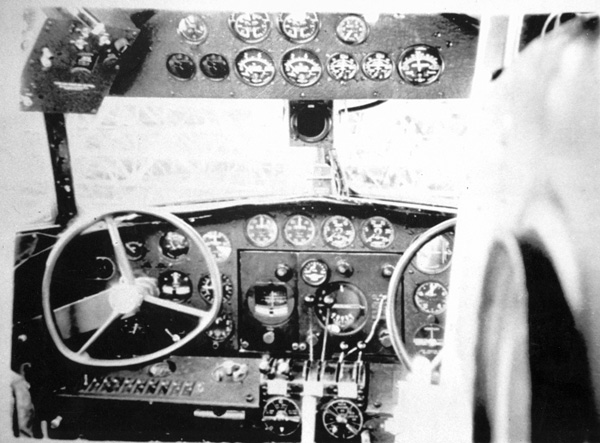

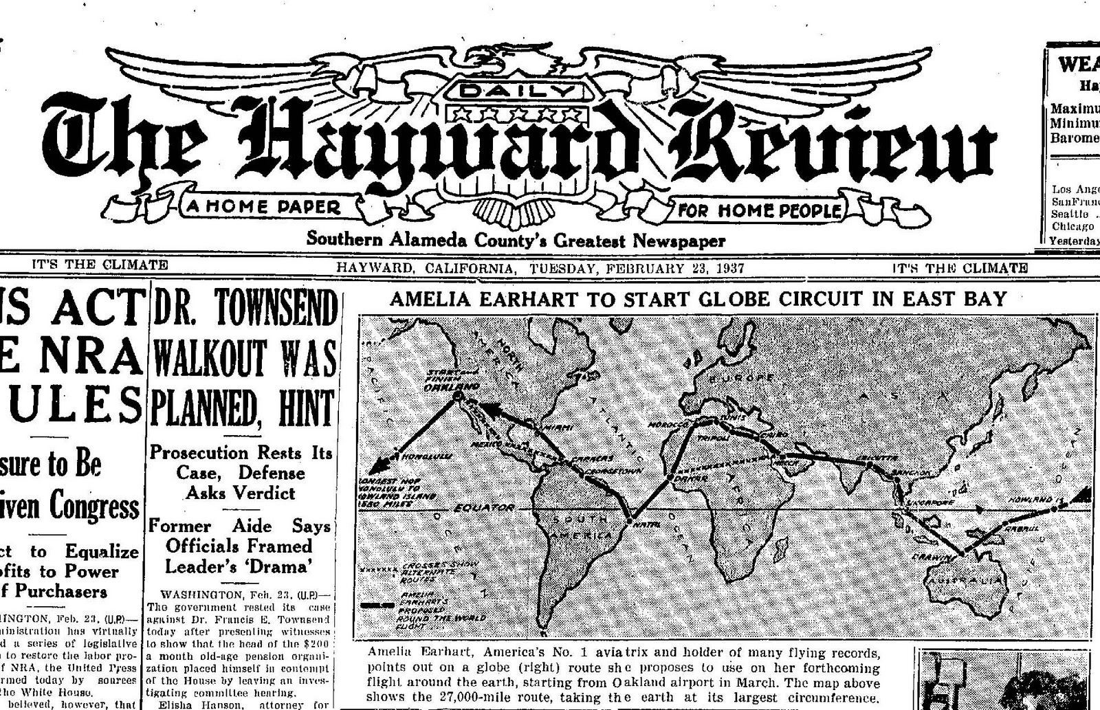

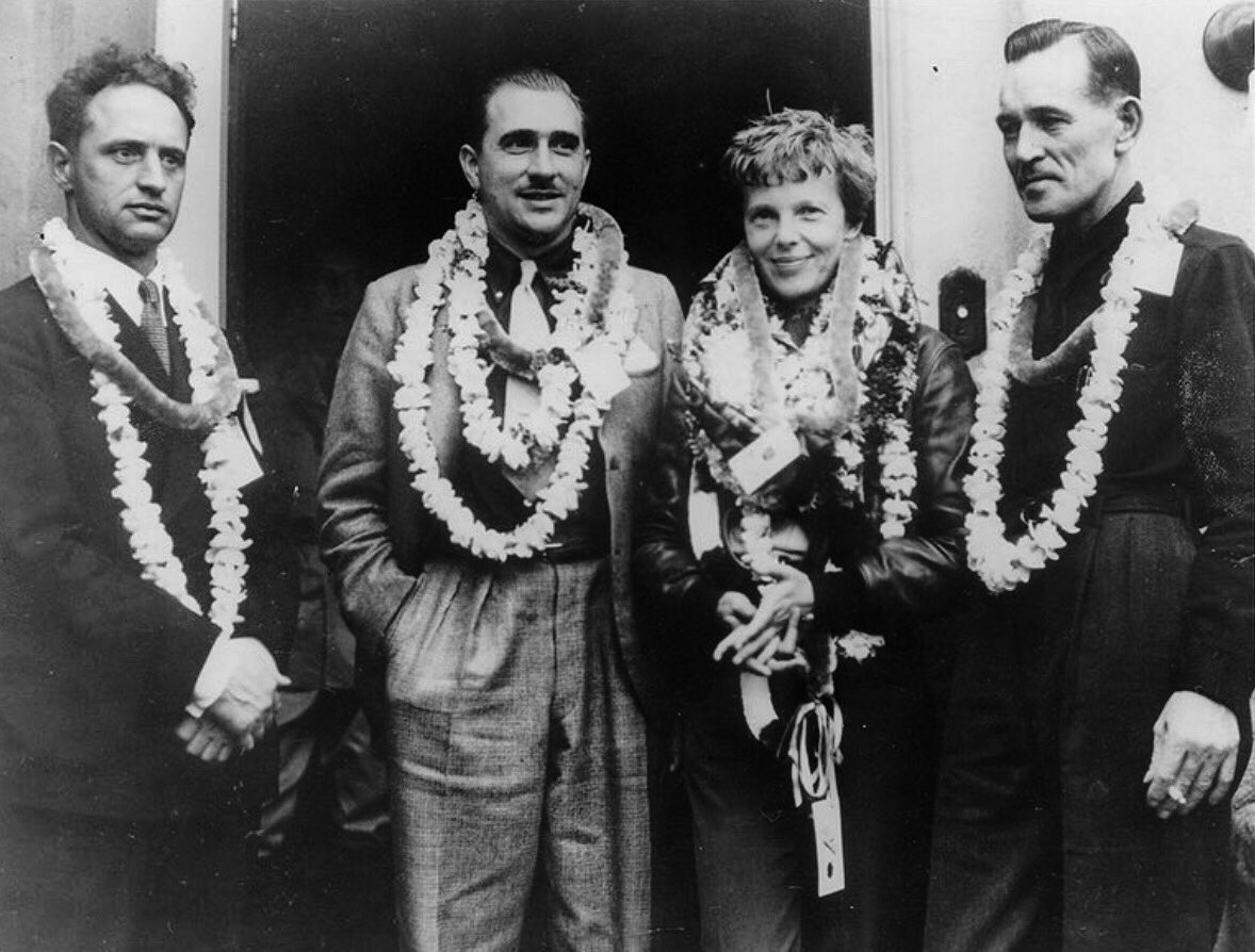

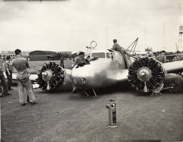
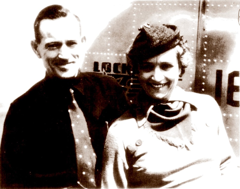

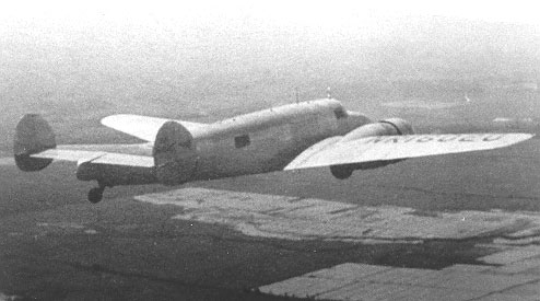
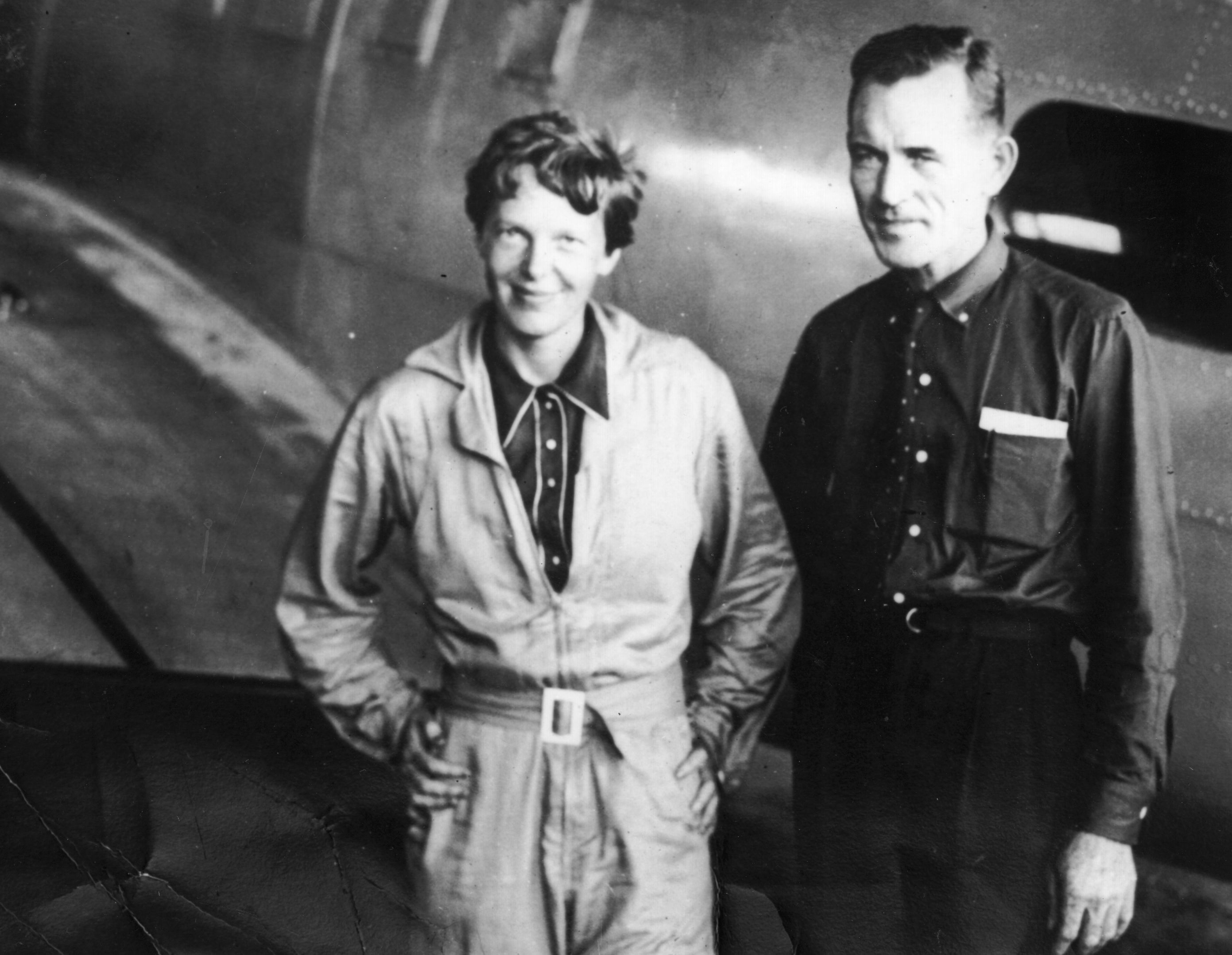


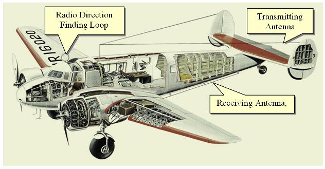
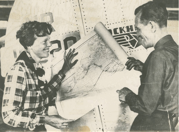
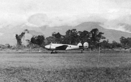
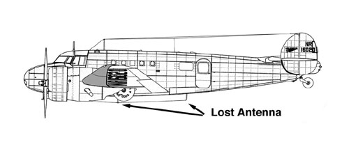


